Back نهر ثومپسون ARZ تومپسون چایی AZB Томпсън (река) Bulgarian Riu Thompson Catalan Thompson River (suba sa Kanada, British Columbia) CEB Томпсон (юханшыв) CV Thompson River (Fraser River) German Río Thompson Spanish Thompson (rivière) French Thompson (fiume) Italian
| Thompson River | |
|---|---|
 | |
 A map of the Thompson River's watershed | |
| Location | |
| Country | Canada |
| Province | British Columbia |
| Land District | Kamloops Division Yale |
| Physical characteristics | |
| Source | Confluence of the North & South Thompson Rivers |
| • location | Kamloops |
| • coordinates | 50°40′49″N 120°20′36″W / 50.68028°N 120.34333°W |
| • elevation | 345 m (1,132 ft) |
| Mouth | Fraser River |
• location | Lytton |
• coordinates | 50°14′07″N 121°35′00″W / 50.23528°N 121.58333°W[1] |
• elevation | 195 m (640 ft) |
| Length | 489 km (304 mi)[2] |
| Basin size | 56,000 km2 (22,000 sq mi)[3] |
| Discharge | |
| • location | Spences Bridge |
| • average | 773 m3/s (27,300 cu ft/s) |
| • minimum | 171 m3/s (6,000 cu ft/s) |
| • maximum | 4,200 m3/s (150,000 cu ft/s) |
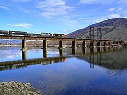
The Thompson River is the largest tributary of the Fraser River,[3] flowing through the south-central portion of British Columbia, Canada. The Thompson River has two main branches, the South Thompson River and the North Thompson River. The river is home to several varieties of Pacific salmon and trout. The area's geological history was heavily influenced by glaciation, and the several large glacial lakes have filled the river valley over the last 12,000 years. Archaeological evidence shows human habitation in the watershed dating back at least 8,300 years. The Thompson was named by Fraser River explorer, Simon Fraser, in honour of his friend, Columbia Basin explorer David Thompson. Recreational use of the river includes whitewater rafting and angling.
- ^ "Thompson River". BC Geographical Names.
- ^ Thompson River Archived 2005-05-10 at the Wayback Machine, The Columbia Gazetteer of North America
- ^ a b Thompson River, BritishColumbia.com