Back Tongatapu ALS تونغاتابو Arabic Тангатапу BE Тонгатапу Bulgarian Tongatapu BS Tongatapu Catalan Tongatapu Island CEB Tongatapu CY Tongatapu German Τονγκατάπου Greek
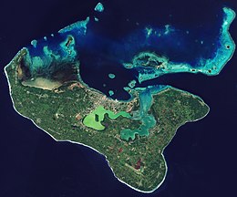
 Satellite picture of Tongatapu | |
 | |
| Geography | |
|---|---|
| Location | Pacific Ocean |
| Coordinates | 21°12′41″S 175°09′11″W / 21.21139°S 175.15306°W |
| Archipelago | Tonga Islands |
| Area | 260.48 km2 (100.57 sq mi) |
| Administration | |
Tonga | |
| Largest settlement | Nukuʻalofa (pop. 23,221) |
| Demographics | |
| Population | 74,454[1] (2021) |
| Pop. density | 273.57/km2 (708.54/sq mi) |
| Ethnic groups | Tongan (majority), European, Chinese, Pacific Islanders. |
Preview warning: Using more than one of the following parameters in Infobox islands:
image_map, map_image.Tongatapu is the main island of Tonga and the site of its capital, Nukuʻalofa. It is located in Tonga's southern island group, to which it gives its name, and is the country's most populous island, with 74,611 residents (2016), 70.5% of the national population, on 260 square kilometres (100 square miles). Tongatapu is Tonga's centre of government and the seat of its monarchy.
Tongatapu has experienced more rapid economic development than the other islands of Tonga, and has thus attracted many internal migrants from them.
- ^ "Tonga's population drops to 100,209". Matangi Tonga. 24 December 2021. Archived from the original on 24 December 2021. Retrieved 24 December 2021.