Back توبيكا (إنديانا) Arabic توپکا، ایندیانا AZB Topeka (Indiana) Catalan Топика (Индиана) CE Topeka (lungsod) CEB Topeka (Indiana) Spanish Topeka (Indiana) EU توپیکا (ایندیانا) FA Topeka (Indiana) French توپکا (اينديانا) GLK
Topeka, Indiana | |
|---|---|
 | |
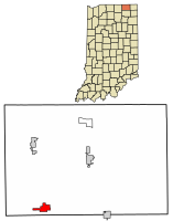
 Location of Topeka in LaGrange County, Indiana. | |
| Coordinates: 41°32′22″N 85°32′51″W / 41.53944°N 85.54750°W | |
| Country | United States |
| State | Indiana |
| County | LaGrange |
| Township | Clearspring, Eden |
| Area | |
• Total | 1.61 sq mi (4.18 km2) |
| • Land | 1.61 sq mi (4.18 km2) |
| • Water | 0.00 sq mi (0.00 km2) |
| Elevation | 929 ft (283 m) |
| Population (2020) | |
• Total | 1,206 |
| • Density | 747.21/sq mi (288.56/km2) |
| Time zone | UTC-5 (Eastern (EST)) |
| • Summer (DST) | UTC-4 (EDT) |
| ZIP code | 46571 |
| Area code | 260 |
| FIPS code | 18-76184[3] |
| GNIS feature ID | 2397697[2] |
| Website | https://topeka-in.gov/ |
Topeka is a town in Clearspring and Eden townships, LaGrange County, Indiana, United States. The population was 1,153 at the 2010 census. Topeka is located approximately eleven miles south of Shipshewana, Indiana.
Topeka was likely so named because the landscape reminded settlers of Topeka, Kansas.[4]
- ^ "2020 U.S. Gazetteer Files". United States Census Bureau. Retrieved March 16, 2022.
- ^ a b U.S. Geological Survey Geographic Names Information System: Topeka, Indiana
- ^ "U.S. Census website". United States Census Bureau. Retrieved January 31, 2008.
- ^ Baker, Ronald L. (October 1995). From Needmore to Prosperity: Hoosier Place Names in Folklore and History. Indiana University Press. p. 326. ISBN 978-0-253-32866-3.
...the surrounding country resembled Topeka, Kansas.