Back Torbay BAT-SMG Torbay (bahin nga lungsod) CEB Torbay (Western Australia) German توربای، استرالیای غربی FA Torbay (Great Southern) Dutch Torbay, Western Australia Swedish
| Torbay Western Australia | |
|---|---|
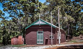
 Torbay Agricultural Hall, opened 25 July 1912[1] | |
 | |
| Coordinates | 35°01′00″S 117°38′00″E / 35.01667°S 117.63333°E |
| Population | 378 (SAL 2021)[2] |
| Established | 1889 |
| Postcode(s) | 6330 |
| Elevation | 69 m (226 ft) |
| Area | 21.5 km2 (8.3 sq mi) |
| Location | |
| LGA(s) | Albany |
| State electorate(s) | Albany |
| Federal division(s) | O'Connor |
Torbay is a small town and a bay in the Great Southern region of Western Australia, 20 kilometres (12 mi) west of Albany. Torbay is within the City of Albany local government area. The Torbay townsite was gazetted in 1910.[3]
The Torbay area is on the eastern fringe of the karri forest region, and with some notable blocks of remnant tall forest. Large granite outcrops are also common. Beaches on the bay tend towards fine white sand. Where streams occur, they are clear but stained dark brown in colour from high-tannin-content vegetation.
Children in the area usually attend schools in Albany, travelling there by school bus. There is also a local independent school, the Woodbury Boston Primary School.
- ^ "Torbay Agricultural Hall - Opening Ceremony". Albany Advertiser. 3 August 1912. p. 3. Retrieved 1 May 2014.
- ^ Australian Bureau of Statistics (28 June 2022). "Torbay (suburb and locality)". Australian Census 2021 QuickStats. Retrieved 28 June 2022.
- ^ "History of country town names – T". Western Australian Land Information Authority. Archived from the original on 14 March 2022. Retrieved 11 February 2007.
