Back Transverse Ranges Catalan زنجیرەکانی ترانسڤێرس CKB Transverse Ranges Czech Transverse Ranges German Cordilleras transversales Spanish Transverse Ranges French Transverse Ranges FRR तिर्यक शृंखलाएं HI Transverse Ranges Dutch Transverse Ranges Polish
| Transverse Ranges | |
|---|---|
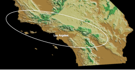
 The ellipse outlines the region of the California Transverse Ranges | |
| Highest point | |
| Peak | San Gorgonio Mountain |
| Elevation | 11,503 ft (3,506 m) |
| Coordinates | 34°05′57″N 116°49′29″W / 34.099162°N 116.824853°W |
| Dimensions | |
| Length | 300 mi (480 km) |
| Geography | |
 | |
| Country | United States |
| Parent range | Pacific Coast Ranges |
The Transverse Ranges are a group of mountain ranges of southern California, in the Pacific Coast Ranges physiographic region in North America. The Transverse Ranges begin at the southern end of the California Coast Ranges and lie within Santa Barbara, Ventura, Los Angeles, San Bernardino, Riverside and Kern counties. The Peninsular Ranges lie to the south. The name is due to the ranges' east–west orientation, making them transverse to the general northwest–southeast orientation of most of California's coastal mountains.[1][2][3][4]
The ranges extend from west of Point Conception eastward approximately 500 kilometers into the Mojave and Colorado Desert. The geology and topography of the ranges express three distinct segments that have contrasting elevations, rock types, and vegetation. The western segment extends to the San Gabriel Mountains and San Gabriel fault. The central segment includes mountains that range eastward to the San Andreas fault. The eastern segment extends from the Cajon Pass at the San Andreas fault eastward to the Colorado Desert.[1] The central and eastern segments (near the San Andreas fault) have the highest elevations.
Most of the ranges lie in the California chaparral and woodlands ecoregion. Lower elevations are dominated by chaparral and scrubland, while higher elevations support large conifer forests. Most of the ranges in the system are fault blocks, and were uplifted by tectonic movements late in the Cenozoic Era. West of Tejon Pass, the primary rock types are varied, with a mix of sedimentary, volcanic, and metamorphic rocks, while regions east of the pass are dominated by plutonic granitic and metasedimentary rocks.[1]
- ^ a b c Dibblee Jr, T.W., 1982. Regional geology of the Transverse Ranges Province of southern California. Geology and mineral wealth of the California Transverse Ranges, 10, pp.7-26.
- ^ Norris, R. M.; Webb, R. W. (1990). Geology of California. Wiley.
- ^ Ingram, Scott (2002). California: The Golden State. Gareth Stevens. pp. 21. ISBN 978-0-8368-5282-0.
- ^ "California's Coastal Mountains". California Coastal Commission. Archived from the original on 2007-12-22. Retrieved 2007-12-25.