Back Wasserscheidepunkt German Vértice hidrográfico Spanish Tripoint hydrographique French Tripelpunt (waterscheiding) Dutch Triponto hidrográfico Portuguese

A triple divide or triple watershed is a point on Earth's surface where three drainage basins meet. A triple divide results from the intersection of two drainage divides. Triple divides range from prominent mountain peaks to minor side peaks, down to simple slope changes on a ridge which are otherwise unremarkable. The elevation of a triple divide can be thousands of meters to barely above sea level. Triple divides are a common hydrographic feature of any terrain that has rivers, streams and/or lakes.
Topographic triple divides do not necessarily respect the underground path of water. Thus, depending on the infiltration and the different geological layers, the hydrologic triple divide is often offset from the topographic triple divide.
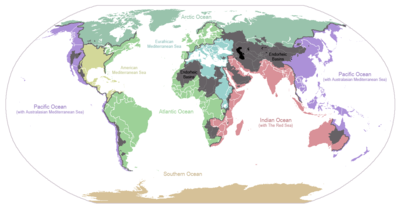
A hydrological apex is a triple divide whose waters flow into three different oceans. Triple Divide Peak in the U.S. state of Montana and, depending on definition, Snow Dome in Canada are the only such places on Earth.[notes 1]
Cite error: There are <ref group=notes> tags on this page, but the references will not show without a {{reflist|group=notes}} template (see the help page).