Back Trossachs German Trossachs Spanish Trossachs French Na Tròisichean GA Na Tròiseachan GD Trossachs (Scozia) Italian Trossachs Dutch Trossachs NN Trossachs SCO Trossachs SL
The Trossachs
| |
|---|---|
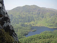
 The forested area at the eastern end of Loch Katrine | |
Location within the Stirling council area | |
| OS grid reference | NN498068 |
| Council area | |
| Country | Scotland |
| Sovereign state | United Kingdom |
| Police | Scotland |
| Fire | Scottish |
| Ambulance | Scottish |
The Trossachs (ⓘ; Scottish Gaelic: Na Tròiseachan) generally refers to an area of wooded glens, braes, and lochs lying to the east of Ben Lomond in the Stirling council area of Scotland. The name is taken from that of a small woodland glen that lies at the centre of the area, but is now generally applied to the wider region.
The wooded hills and lochs of the area may be considered to represent a microcosm of a typical highland landscape,[1] and the woodlands are an important habitat for many species.[2] Much of the Trossachs area is protected by various different conservation designations, including the Great Trossachs Forest National Nature Reserve.[3]
The Trossachs form part of the Loch Lomond and The Trossachs National Park, which was established in 2002.[4] The area has long been visited by tourists due to the relative proximity of major population centres such as Glasgow and Stirling, and remains popular with walkers, cyclists and tourists.[1] Scenic boat rides on Loch Katrine are popular with visitors: the steamer SS Sir Walter Scott, launched in 1899, remains in operation.[5] The Great Trossachs Path, one of Scotland's Great Trails, is a 48 km route suitable for walkers, cyclists and horse riders. It runs between Callander in the east and Inversnaid on the banks of Loch Lomond in the west, passing along the northern shores of Loch Katrine and Loch Arklet.[6]
- ^ a b Cite error: The named reference
SMCwas invoked but never defined (see the help page). - ^ Cite error: The named reference
qualitieswas invoked but never defined (see the help page). - ^ "Sitelink - Map Search". NatureScot. Retrieved 16 September 2020.
- ^ "National park 'goes live'". BBC News. 8 July 2002.
- ^ "Loch Katrine - Loch Cruises". Steamship Sir Walter Scott Ltd. Retrieved 19 June 2018.
- ^ "What is the Great Trossachs Path". The Great Trossachs Forest. Retrieved 20 June 2018.
