Back مقاطعة فنتون (أوهايو) Arabic Vinton County, Ohio BAR Винтън (окръг, Охайо) Bulgarian ভিনটোন কাউন্টি, ওহাইও BPY Vinton Gông (Ohio) CDO Vinton County CEB Vinton County, Ohio CY Vinton County Danish Vinton County German Condado de Vinton Spanish
Vinton County | |
|---|---|
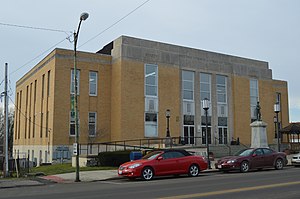
 Vinton County Courthouse in McArthur | |
 Location within the U.S. state of Ohio | |
 Ohio's location within the U.S. | |
| Coordinates: 39°15′N 82°29′W / 39.25°N 82.49°W | |
| Country | |
| State | |
| Founded | March 23, 1850[1] |
| Named for | Samuel Finley Vinton |
| Seat | McArthur |
| Largest village | McArthur |
| Area | |
• Total | 415 sq mi (1,070 km2) |
| • Land | 412 sq mi (1,070 km2) |
| • Water | 2.6 sq mi (7 km2) 0.6% |
| Population (2020) | |
• Total | 12,800 |
• Estimate (2023) | 12,474 |
| • Density | 31/sq mi (12/km2) |
| Time zone | UTC−5 (Eastern) |
| • Summer (DST) | UTC−4 (EDT) |
| Congressional district | 2nd |
| Website | http://www.vintoncounty.com/ |
Vinton County is a county located in the U.S. state of Ohio. As of the 2020 census, the population was 12,800,[2] making it the least populous county of Ohio. Its county seat is McArthur.[3] The county is named for Samuel Finley Vinton, US Representative from Ohio (1823–37, 1843–51).[4]
- ^ "Ohio County Profiles: Vinton County" (PDF). Ohio Department of Development. Archived from the original (PDF) on June 21, 2007. Retrieved April 28, 2007.
- ^ "U.S. Census Bureau QuickFacts: Hamilton County, Ohio". www.census.gov. United States Census Bureau. Retrieved June 26, 2022.
- ^ "Find a County". National Association of Counties. Archived from the original on May 31, 2011. Retrieved June 7, 2011.
- ^ "Vinton County data". Ohio State University Extension Data Center. Retrieved April 28, 2007.[dead link]

