Back Vlissingen AF فليسنجن Arabic فليسنجن ARZ Флісінген BE Vlissingen BR Vlissingen Catalan Gemeente Vlissingen CEB Vlissingen Czech Vlissingen CY Vlissingen Danish
Vlissingen
Vlissienge (Zeeuws) Flushing | |
|---|---|
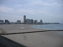
Boulevard with beach Harbour | |
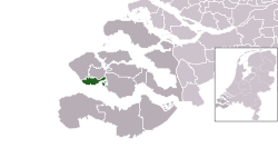
 Location in Zeeland | |
| Coordinates: 51°27′N 3°34′E / 51.450°N 3.567°E | |
| Country | Netherlands |
| Province | Zeeland |
| Boroughs | 8 Districts
|
| Government | |
| • Body | Municipal council |
| • Mayor | Bas van den Tillaar (CDA) |
| Area | |
• Total | 344.84 km2 (133.14 sq mi) |
| • Land | 34.31 km2 (13.25 sq mi) |
| • Water | 310.53 km2 (119.90 sq mi) |
| Elevation | 1 m (3 ft) |
| Population (January 2021)[4] | |
• Total | 44,358 |
| • Density | 1,293/km2 (3,350/sq mi) |
| Demonym | Vlissinger |
| Time zone | UTC+1 (CET) |
| • Summer (DST) | UTC+2 (CEST) |
| Postcode | 4380–4389 |
| Area code | 0118 |
| Website | vlissingen |
Vlissingen (Dutch: [ˈvlɪsɪŋə(n)] ⓘ; Zeelandic: Vlissienge) is a municipality and a city in the southwestern Netherlands on the island of Walcheren. With its strategic location between the Scheldt river and the North Sea, Vlissingen has been an important harbour for centuries. It was granted city rights in 1315. In the 17th century the roadstead of Vlissingen was a main harbour for ships of the Dutch East India Company (VOC). It is also known as the birthplace of Lieutnant-Admiral Michiel de Ruyter.
Vlissingen is mainly noted for the yards on the Scheldt where most of the ships of the Royal Netherlands Navy (Koninklijke Marine) are built.
- ^ "Burgemeester Letty Demmers-van der Geest" [Mayor Letty Demmers-van der Geest] (in Dutch). Gemeente Vlissingen. Archived from the original on 24 December 2013. Retrieved 22 December 2013.
- ^ "Kerncijfers wijken en buurten 2020" [Key figures for neighbourhoods 2020]. StatLine (in Dutch). CBS. 24 July 2020. Retrieved 19 September 2020.
- ^ "Postcodetool for 4382MA". Actueel Hoogtebestand Nederland (in Dutch). Het Waterschapshuis. Retrieved 22 December 2013.
- ^ "Bevolkingsontwikkeling; regio per maand" [Population growth; regions per month]. CBS Statline (in Dutch). CBS. 1 January 2021. Retrieved 2 January 2022.


