Wallaceville | |
|---|---|
Suburb | |
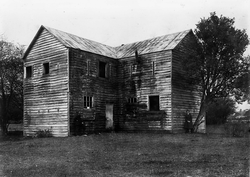
 Blockhouse in Wallaceville, 1919 | |
 | |
| Coordinates: 41°07′48″S 175°03′29″E / 41.130°S 175.058°E | |
| Country | New Zealand |
| Region | Wellington Region |
| Territorial authority | Upper Hutt |
| Electorates | |
| Government | |
| • Territorial Authority | Upper Hutt City Council |
| • Regional council | Greater Wellington Regional Council |
| • Mayor of Upper Hutt | Wayne Guppy |
| • Remutaka MP | Chris Hipkins |
| • Ikaroa-Rāwhiti MP | Cushla Tangaere-Manuel |
| Area | |
• Total | 0.70 km2 (0.27 sq mi) |
| Population (June 2024)[2] | |
• Total | 2,530 |
| • Density | 3,600/km2 (9,400/sq mi) |
Wallaceville is a suburb of Upper Hutt (located in the lower (southern) North Island of New Zealand). It is named after John Howard Wallace, an early New Zealand settler, council politician, businessman and author of one of the first published histories of New Zealand.[3]
The suburb is home to the oldest surviving wooden blockhouse in New Zealand,[4] and is served by Wallaceville Railway Station.
- ^ Cite error: The named reference
Areawas invoked but never defined (see the help page). - ^ "Aotearoa Data Explorer". Statistics New Zealand. Retrieved 26 October 2024.
- ^ Wallace, John Howard (1886). Manual of New Zealand History (1 ed.). Wellington, New Zealand: Edwards & Green. p. i. Retrieved 12 August 2019.
By J. Howard Wallace, One of the Pioneer Settlers of the Colony (January 22, 1840). Eight Years Chairman of Committees in the Wellington Provincial Council. Author of 'The Early History of New Zealand.'
- ^ "Upper Hutt Blockhouse". New Zealand Heritage List/Rārangi Kōrero. Heritage New Zealand. Retrieved 1 December 2009.
