Back والنوت (كاليفورنيا) Arabic والنوت (كاليفورنيا) ARZ والنات، کالیفورنیا AZB Уолнът (град, Калифорния) Bulgarian Walnut (Califòrnia) Catalan Волнат (Калифорни) CE Walnut (lungsod sa Tinipong Bansa, California) CEB Walnut (Kalifornien) German Walnut (Kalifornio) EO Walnut (California) Spanish
Walnut, California | |
|---|---|
 View of Mt. San Antonio College and surrounding area | |
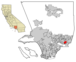
 Location of Walnut in Los Angeles County, California | |
| Coordinates: 34°2′N 117°52′W / 34.033°N 117.867°W | |
| Country | United States |
| State | California |
| County | Los Angeles |
| Incorporated (city) | January 19, 1959[1] |
| Named for | Rancho Los Nogales (lit. 'Ranch of the Walnut Trees') |
| Government | |
| • Type | Council-Manager |
| • Mayor | Linda Freedman[2] |
| • Mayor Pro Tem | Eric Ching[2] |
| • Council Member | Nancy Tragarz[2] |
| • Council Member | Ritchie Cajulis[2] |
| • Council Member | Allen Wu[2] |
| Area | |
• Total | 9.00 sq mi (23.30 km2) |
| • Land | 8.99 sq mi (23.29 km2) |
| • Water | 0.00 sq mi (0.01 km2) 0.04% |
| Elevation | 561 ft (171 m) |
| Population | |
• Total | 28,430 |
| • Density | 3,301.4/sq mi (1,274.67/km2) |
| Time zone | UTC-8 (PST) |
| • Summer (DST) | UTC-7 (PDT) |
| ZIP Codes | 91788, 91789, 91795[6] |
| Area code(s) | 909, 626 |
| FIPS code | 06-83332 |
| GNIS feature IDs | 1652808, 2412173 |
| Website | www |
Walnut is a city in the eastern part of Los Angeles County in the U.S. state of California.[7] According to the 2010 census, the city had a population of 29,172,[8] and the population was estimated to be 29,685 in 2019.[9]
The greater Walnut Valley is located between the steep San Jose Hills to the north and the gently sloping Puente Hills to the south. Quality housing consists of master-planned single family homes ranging in size from 1,800 to 11,200 sq ft (170 to 1,040 m2). The city hosts a highly ranked public school system: the Walnut Valley Unified School District, which has been ranked by numerous sources as one of the top public school districts in Southern California,[10] as well as Mt. San Antonio College.
The city covers nearly 9 sq mi (23 km2) and is home to hundreds of businesses. According to the 2010 United States Census, Walnut has a median household income at one of the top-earning percentiles in the country at $101,250.[11]
The city's name is derived from the Rancho Los Nogales Mexican land grant, nogales being the Spanish word for "walnut trees"; the native California black walnut is a common tree, native to the San Jose Hills. The City of Walnut is a general law city incorporated on January 19, 1959. It is governed by a city council/city manager form of government. A five-member city council is elected by the residents, and a mayor is elected annually by the council to serve a twelve-month term. A city manager is appointed by the council to oversee the daily activities of the city.
- ^ "California Cities by Incorporation Date". California Association of Local Agency Formation Commissions. Archived from the original (Word) on November 3, 2014. Retrieved August 25, 2014.
- ^ a b c d e "Walnut City Council". City of Walnut. Retrieved June 27, 2023.
- ^ "2019 U.S. Gazetteer Files". United States Census Bureau. Retrieved July 1, 2020.
- ^ "Walnut". Geographic Names Information System. United States Geological Survey, United States Department of the Interior. Retrieved February 23, 2015.
- ^ "US Census Bureau". www.census.gov. Retrieved September 15, 2024.
- ^ "USPS – ZIP Code Lookup – Find a ZIP+ 4 Code By City Results". Retrieved January 18, 2007.
- ^ "About the City of Walnut". Archived from the original on June 5, 2016. Retrieved March 10, 2015.
- ^ "Geographic Identifiers: 2010 Census Summary File 1 (G001), Walnut city, California". American FactFinder. U.S. Census Bureau. Archived from the original on February 13, 2020. Retrieved September 4, 2019.
- ^ "Population and Housing Unit Estimates". Retrieved May 21, 2020.
- ^ "Best School Districts for Your Buck in Southern California". June 29, 2015.
- ^ "Census data". quickfacts.census.gov.
