Wanneroo Road | |
|---|---|
 | |
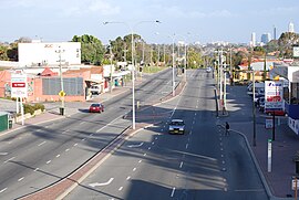
| Looking south, towards Perth in Tuart Hill | |
 | |
| General information | |
| Type | Highway |
| Length | 43.6 km (27 mi) |
| Opened | 1920s |
| Route number(s) | |
| Major junctions | |
| South end | |
| |
| North end | |
| Location(s) | |
| Major suburbs | Tuart Hill, Wanneroo, Yanchep |
| Highway system | |
| ---- | |
Wanneroo Road is a 44-kilometre (27 mi) arterial highway in the northern suburbs of Perth, Western Australia linking Joondanna and Yokine in the south with Wanneroo and Yanchep in the north. As part of State Route 60, it begins from Charles Street in the inner city and becomes Indian Ocean Drive up to Dongara.
Originally a narrow and often country road with a single lane in each direction it has been periodically widened and (particularly north of Wanneroo) straightened. Around the Carabooda area the road has been realigned. Short sections of the original, narrow road remain providing access to properties and businesses along the road.
The road is also multiplexed with State Routes 81 and 83 for short lengths.
