Back واباتو Arabic واباتو ARZ واپاتو، واشینقتون AZB Уопатоу Bulgarian Wapato Catalan Вапато (Вашингтон) CE Wapato CEB Wapato, Washington CY Wapato (Washington) Spanish Wapato (Washington) EU
Wapato, Washington | |
|---|---|
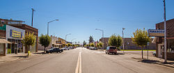
 Wapato Avenue | |
 Location of Wapato, Washington | |
| Coordinates: 46°26′37″N 120°25′17″W / 46.44361°N 120.42139°W | |
| Country | United States |
| State | Washington |
| County | Yakima |
| Founded | 1885 |
| Incorporated | September 16, 1908 |
| Area | |
• Total | 1.16 sq mi (2.99 km2) |
| • Land | 1.16 sq mi (2.99 km2) |
| • Water | 0.00 sq mi (0.00 km2) |
| Elevation | 853 ft (260 m) |
| Population | |
• Total | 4,607 |
• Estimate (2022)[4] | 4,513 |
| • Density | 4,333.91/sq mi (1,673.42/km2) |
| Time zone | UTC-8 (Pacific (PST)) |
| • Summer (DST) | UTC-7 (PDT) |
| ZIP code | 98951 |
| Area code | 509 |
| FIPS code | 53-76125 |
| GNIS feature ID | 2412178[2] |
| Website | wapato-city.org |
Wapato (/ˈwɑːpʌtoʊ/) is a town in Yakima County, Washington, United States. The population was 4,607 at the 2020 census.[3] It has a Hispanic majority.
- ^ "2019 U.S. Gazetteer Files". United States Census Bureau. Retrieved August 7, 2020.
- ^ a b U.S. Geological Survey Geographic Names Information System: Wapato, Washington
- ^ a b "Explore Census Data". United States Census Bureau. Retrieved November 4, 2023.
- ^ Cite error: The named reference
USCensusEst2022was invoked but never defined (see the help page).