Back مقاطعة واشنطن (جورجيا) Arabic واشينطون كاونتى (جورجيا) ARZ Washington County, Georgia BAR Вашингтон (окръг, Джорджия) Bulgarian ৱাশিংটন কাউন্টি, জর্জিয়া BPY Washington Gông (Georgia) CDO Вашингтон (гуо, Джорджи) CE Washington County (kondado sa Tinipong Bansa, Georgia) CEB Washington County, Georgia CY Washington County (Georgia) German
Washington County | |
|---|---|
 County courthouse | |
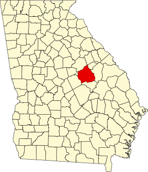
 Location within the U.S. state of Georgia | |
 Georgia's location within the U.S. | |
| Coordinates: 32°58′N 82°47′W / 32.97°N 82.79°W | |
| Country | |
| State | |
| Founded | February 25, 1784 |
| Named for | George Washington |
| Seat | Sandersville |
| Largest city | Sandersville |
| Area | |
• Total | 684 sq mi (1,770 km2) |
| • Land | 678 sq mi (1,760 km2) |
| • Water | 5.9 sq mi (15 km2) 0.9% |
| Population (2020) | |
• Total | 19,988 |
• Estimate (2023) | 19,820 |
| • Density | 29/sq mi (11/km2) |
| Time zone | UTC−5 (Eastern) |
| • Summer (DST) | UTC−4 (EDT) |
| Congressional district | 12th |
| Website | washingtoncountyga |
Washington County is a county located in the U.S. state of Georgia. As of the 2020 census, the population was 19,988.[1][2] The county seat is Sandersville.[3] The county was established on February 25, 1784. It was named for Revolutionary War general and President of the United States George Washington.[4]
- ^ "State & County QuickFacts". United States Census Bureau. Retrieved June 27, 2014.
- ^ U.S. 2020 Census Bureau report, Washington County, Georgia
- ^ "Find a County". National Association of Counties. Retrieved June 7, 2011.
- ^ Krakow, Kenneth K. (1975). Georgia Place-Names: Their History and Origins (PDF). Macon, GA: Winship Press. p. 247. ISBN 0-915430-00-2. Archived (PDF) from the original on July 27, 2003.