Back مقاطعة واشنطن (أوريغون) Arabic واشينطون كاونتى (اوريجون) ARZ Washington County, Oregon BAR Уошингтън (окръг, Орегон) Bulgarian ৱাশিংটন কাউন্টি, অরেগন BPY Washington Gông (Oregon) CDO Вашингтон (гуо, Орегон) CE Washington County (kondado sa Tinipong Bansa, Oregon) CEB Washington County (Oregon) Czech Washington County, Oregon CY
Washington County | |
|---|---|
|
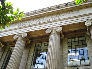
From top, left to right: Washington County courthouse, Meier Road Barn, a canola field in rural Washington County | |
 Location within the U.S. state of Oregon | |
 Oregon's location within the U.S. | |
| Coordinates: 45°34′N 123°05′W / 45.56°N 123.09°W | |
| Country | |
| State | |
| Founded | July 5, 1843 (as Twality District) |
| Named for | George Washington |
| Seat | Hillsboro |
| Largest city | Hillsboro |
| Area | |
• Total | 726 sq mi (1,880 km2) |
| • Land | 724 sq mi (1,880 km2) |
| • Water | 2.2 sq mi (6 km2) 0.3% |
| Population (2020) | |
• Total | 600,372 |
• Estimate (2023) | 598,865 |
| • Density | 830/sq mi (320/km2) |
| Time zone | UTC−8 (Pacific) |
| • Summer (DST) | UTC−7 (PDT) |
| Congressional districts | 1st, 6th |
| Website | washingtoncountyor.gov |
Washington County is one of 36 counties in the U.S. state of Oregon and part of the Portland metropolitan area. The 2020 census recorded the population as 600,372,[1] making it the second most populous county in the state and most populous "Washington County" in the United States. Hillsboro is the county seat and largest city,[2][3] while other major cities include Beaverton, Tigard, Cornelius, Banks, Gaston, Sherwood, North Plains, and Forest Grove, the county's oldest city.[4] Originally named Twality when created in 1843, the Oregon Territorial Legislature renamed it for the nation's first president in 1849 and included the entire northwest corner of Oregon before new counties were created in 1854. The Tualatin River and its drainage basin lie almost entirely within the county, which shares its boundaries with the Tualatin Valley. It is bordered on the west and north by the Northern Oregon Coast Range, on the south by the Chehalem Mountains, and on the north and east by the Tualatin Mountains, or West Hills.
Major roads include sections of Interstate 5 and 205, the Sunset Highway, Oregon Route 217, 47, 10, 6 and 8. Public transportation is primarily operated by TriMet and includes buses, the Westside Express Service commuter rail, and MAX Light Rail. Other transportation includes air travel at Hillsboro Airport, private airfields and heliports, and heavy rail cargo on rail lines.
- ^ "State & County QuickFacts". United States Census Bureau. Retrieved April 21, 2023.
- ^ Proehl, Risa S. (March 2009). "2008 Oregon Population Report" (PDF). Population Research Center. Portland State University. p. 7. Archived from the original (PDF) on March 3, 2016. Retrieved May 5, 2009.
- ^ "Find a County". National Association of Counties. Retrieved June 7, 2011.
- ^ "Incorporation dates". The Hillsboro Argus. October 19, 1976. pp. Communities, p. 21.


