Back واتربوري Arabic واتربورى ARZ واتربوری، کانتیکت AZB Уотэрберы (Канектыкут) BE Уотърбъри (Кънектикът) Bulgarian Waterbury (Connecticut) Catalan Вотербери (Коннектикут) CE Waterbury (lungsod sa Tinipong Bansa, Connecticut) CEB Waterbury CH واتەربێری CKB
Waterbury | |
|---|---|
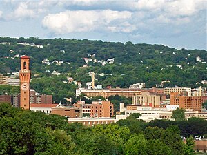
 Waterbury skyline from the west, with Union Station clock tower at left | |
| Nickname: The Brass City, | |
| Motto(s): Quid Aere Perennius (Latin) "What Is More Lasting Than Brass?" | |
| Coordinates: 41°33′22″N 73°2′29″W / 41.55611°N 73.04139°W | |
| Country | United States |
| U.S. state | Connecticut |
| County | New Haven |
| Region | Naugatuck Valley |
| Incorporated (town) | 1686 |
| Incorporated (city) | 1853 |
| Consolidated | 1902 |
| Government | |
| • Type | Mayor–council |
| • Mayor | Paul K. Pernerewski Jr. (D) |
| Area | |
• City | 28.94 sq mi (74.97 km2) |
| • Land | 28.52 sq mi (73.87 km2) |
| • Water | 0.42 sq mi (1.09 km2) 1.45% |
| Elevation | 270 ft (82 m) |
| Highest elevation | 820 ft (250 m) |
| Lowest elevation | 220 ft (67 m) |
| Population | |
• City | 114,403 (US: 258th) |
• Estimate (2023)[3] | 114,990 |
| • Urban | 199,317 (US: 195th) |
| • Urban density | 2,156.2/sq mi (832.5/km2) |
| • Metro | 454,083 (US: 118th) |
| • Metro density | 1,090.13/sq mi (420.90/km2) |
| Time zone | UTC−05:00 (Eastern) |
| • Summer (DST) | UTC−04:00 (Eastern) |
| ZIP Codes | 06701–06720 |
| Area code(s) | 203/475 |
| FIPS code | 09-80000 |
| GNIS feature ID | 0211851 |
| Airport | Waterbury–Oxford Airport |
| Interstates | |
| State Routes | |
| Commuter rail | |
| Website | www |
Waterbury is a city in the U.S. state of Connecticut. Waterbury had a population of 114,403 as of the 2020 Census.[2] The city is 33 miles (53 km) southwest of Hartford and 77 miles (124 km) northeast of New York City. Waterbury is the largest city in the Naugatuck Valley Planning Region and second-largest city in New Haven County.
Throughout the first half of the 20th century, Waterbury had large industrial interests and was the leading center in the United States for the manufacture of brassware (including castings and finishings), as reflected in the nickname the "Brass City" and the city's motto Quid Aere Perennius? ("What Is More Lasting Than Brass?"). It was also noted for the manufacture of watches and clocks (Timex).
The city is alongside Interstate 84 (Yankee Expressway) and Route 8 and has a Metro-North railroad station with connections to Grand Central Terminal. Waterbury is also home to Post University and the regional campuses of the University of Connecticut, University of Bridgeport, Western Connecticut State University as well as Naugatuck Valley Community College.
- ^ "2019 U.S. Gazetteer Files". United States Census Bureau. Archived from the original on March 21, 2021. Retrieved July 2, 2020.
- ^ a b Cite error: The named reference
USCensus2020was invoked but never defined (see the help page). - ^ "QuickFacts - Waterbury town, Naugatuck Valley Planning Region, Connecticut; United States". www.census.gov.
- ^ "List of 2020 Census Urban Areas". census.gov. United States Census Bureau. Retrieved January 8, 2023.
- ^ "Revised Delineations of Metropolitan Statistical Areas, Micropolitan Statistical Areas, and Combined Statistical Areas, and Guidance on Uses of the Delineations of These Areas" (PDF). www.whitehouse.gov. Executive Office of the President.


