Back واتكينسفيل (جورجيا) Arabic واتکینسویل، جورجیا AZB Воткинсвилл (Джорджи) CE Watkinsville CEB Watkinsville, Georgia CY Watkinsville Spanish Watkinsville (Georgia) EU واتکینسویل، جورجیا FA Watkinsville French واتکینزویل (جؤرجيا) GLK
Watkinsville, Georgia | |
|---|---|
 Oconee County Courthouse in Watkinsville, Georgia | |
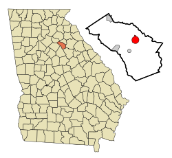
 Location in Oconee County and the state of Georgia | |
| Coordinates: 33°51′46″N 83°24′29″W / 33.86278°N 83.40806°W | |
| Country | United States |
| State | Georgia |
| County | Oconee |
| Area | |
• Total | 3.31 sq mi (8.58 km2) |
| • Land | 3.28 sq mi (8.48 km2) |
| • Water | 0.04 sq mi (0.10 km2) |
| Elevation | 735 ft (224 m) |
| Population (2020) | |
• Total | 2,896 |
| • Density | 884.00/sq mi (341.36/km2) |
| Time zone | UTC-5 (Eastern (EST)) |
| • Summer (DST) | UTC-4 (EDT) |
| ZIP code | 30677 |
| Area code | 706 |
| FIPS code | 13-80788[3] |
| GNIS feature ID | 2405687[2] |
| Website | cityofwatkinsville |
Watkinsville is the largest city and county seat of Oconee County, Georgia, United States. As of the 2020 census, the city had a total population of 2,896. It served as the seat of Clarke County until 1872 when the county seat of that county was moved to Athens, a move which ultimately led to the creation of Oconee County in 1875. It is included in the Athens-Clarke County, Georgia Metropolitan Statistical Area.
- ^ "2020 U.S. Gazetteer Files". United States Census Bureau. Retrieved December 18, 2021.
- ^ a b U.S. Geological Survey Geographic Names Information System: Watkinsville, Georgia
- ^ "U.S. Census website". United States Census Bureau. Retrieved January 31, 2008.