Back Wedmore (lungsod) CEB Wedmore Spanish Wedmore EU ودمور FA Wedmore French Wedmore Italian Wedmore LLD Wedmore Dutch Wedmore NB Wedmore Polish
| Wedmore | |
|---|---|
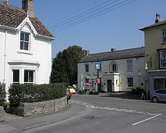
 The junction between Church Street and The Borough, in the centre of Wedmore | |
Location within Somerset | |
| Population | 3,318 (2011) |
| OS grid reference | ST4347 |
| Civil parish |
|
| Unitary authority | |
| Ceremonial county | |
| Region | |
| Country | England |
| Sovereign state | United Kingdom |
| Post town | WEDMORE |
| Postcode district | BS28 |
| Dialling code | 01934 |
| Police | Avon and Somerset |
| Fire | Devon and Somerset |
| Ambulance | South Western |
| UK Parliament | |
Wedmore is a large village and civil parish in the county of Somerset, England.[1] It is situated on raised ground, in the Somerset Levels between the River Axe and River Brue, often called the Isle of Wedmore. The parish consists of three main villages: Wedmore, Blackford and Theale, with the 17 hamlets of Bagley, Blakeway, Clewer, Crickham, Cocklake, Heath House, Latcham, Little Ireland, Middle Stoughton, Mudgley, Panborough, Sand, Stoughton Cross, Washbrook, West End, West Ham and West Stoughton. The parish of Wedmore has a population of 3,318 according to the 2011 census.[2]
Its facilities include a medical and dental practice, pharmacy, butcher's, a village store with off licence, three pubs, restaurant, café and several other local shops. It is 4 miles (6 km) south of Cheddar, 7 miles (11 km) west of the city of Wells and 7 miles (11 km) north west of Glastonbury.
- ^ "Welcome to the Official Website of Wedmore Parish Council". Wedmore parish Council. Retrieved 30 September 2009.
- ^ "Statistics for Wards, LSOAs and Parishes - SUMMARY Profiles" (Excel). Somerset Intelligence. Retrieved 4 January 2014.
