Back Weesp AN فيسب (هولندا) Arabic فيسب (تجمع سكان فى هولندا الشماليه) ARZ Weesp BAN Весп BE Weesp BR Weesp Catalan Weesp (lungsod sa Olandres) CEB Weesp Czech Weesp German
Weesp | |
|---|---|
|
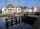
Images, from top down, left to right: 't Haantje windmill, Herengracht, city docks and Vechtstreek | |
 Location in North Holland | |
| Coordinates: 52°18′N 5°3′E / 52.300°N 5.050°E | |
| Country | Netherlands |
| Province | North Holland |
| Municipality | Amsterdam |
| Area | |
• Total | 24.16 km2 (9.33 sq mi) |
| • Land | 22.79 km2 (8.80 sq mi) |
| • Water | 1.37 km2 (0.53 sq mi) |
| Elevation | 1 m (3 ft) |
| Population (January 2021)[3] | |
• Total | 20,445 |
| • Density | 897/km2 (2,320/sq mi) |
| Demonym | Weesper |
| Time zone | UTC+1 (CET) |
| • Summer (DST) | UTC+2 (CEST) |
| Postcode | 1380–1384 |
| Area code | 0294 |
| Website | www |

Weesp (Dutch pronunciation: [ʋeːsp] ) is a city and an urban area in the municipality of Amsterdam in the province of North Holland, Netherlands. It had a population of 20,445 in 2021. It lies on the river Vecht and next to the Amsterdam–Rhine Canal in an area called the Vechtstreek. The former municipality of Weesp merged with Amsterdam on 24 March 2022.[4][5]
- ^ "Kerncijfers wijken en buurten 2020" [Key figures for neighbourhoods 2020]. StatLine (in Dutch). CBS. 24 July 2020. Retrieved 19 September 2020.
- ^ "Postcodetool for 1381BD". Actueel Hoogtebestand Nederland (in Dutch). Het Waterschapshuis. Retrieved 24 March 2014.
- ^ "Bevolkingsontwikkeling; regio per maand" [Population growth; regions per month]. CBS Statline (in Dutch). CBS. 1 January 2021. Retrieved 2 January 2022.
- ^ Cite error: The named reference
herindelingwas invoked but never defined (see the help page). - ^ Cite error: The named reference
weespermopwas invoked but never defined (see the help page).


