Back ويست كنيبونك (مين) Arabic وزت کنبونک، مئین AZB West Kennebunk CEB West Kennebunk Spanish West Kennebunk (Maine) EU وست کنبانک، مین FA وست کنبانک (مین) GLK West Kennebunk (Maine) LLD West Kennebunk Polish West Kennebunk, Maine SH
West Kennebunk, Maine | |
|---|---|
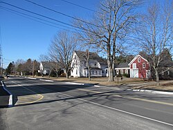
 Alfred Road | |
| Coordinates: 43°24′32″N 70°34′43″W / 43.40889°N 70.57861°W | |
| Country | United States |
| State | Maine |
| County | York |
| Area | |
• Total | 3.48 sq mi (9.01 km2) |
| • Land | 3.48 sq mi (9.01 km2) |
| • Water | 0.00 sq mi (0.00 km2) |
| Elevation | 141 ft (43 m) |
| Population (2020) | |
• Total | 1,191 |
| • Density | 342.34/sq mi (132.18/km2) |
| Time zone | UTC-5 (Eastern (EST)) |
| • Summer (DST) | UTC-4 (EDT) |
| ZIP code | 04094 |
| Area code | 207 |
| FIPS code | 23-83330 |
| GNIS feature ID | 0578164 |
West Kennebunk is a census-designated place (CDP) in the town of Kennebunk in York County, Maine, United States. The population was 1,176 at the 2010 census.[2] It is part of the Portland–South Portland–Biddeford, Maine Metropolitan Statistical Area.
- ^ "2020 U.S. Gazetteer Files". United States Census Bureau. Retrieved April 8, 2022.
- ^ "Geographic Identifiers: 2010 Demographic Profile Data (G001): West Kennebunk CDP, Maine". U.S. Census Bureau, American Factfinder. Archived from the original on February 12, 2020. Retrieved January 29, 2013.
