Back Whitburn (lungsod sa Hiniusang Gingharian, Inglatera) CEB Whitburn, Tyne and Wear CY Whitburn (Tyne eta Wear) EU وایتبرن، تاین و ور FA Whitburn (Anglia) Polish Whitburn (Tyne and Wear) Portuguese Whitburn, England Swedish
| Whitburn | |
|---|---|
| Village | |
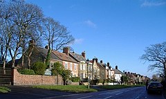
 Houses on Front Street, Whitburn | |
Location within Tyne and Wear | |
| Population | 7,448 [a] |
| OS grid reference | NZ 40798 61943 |
| Metropolitan borough | |
| Metropolitan county | |
| Region | |
| Country | England |
| Sovereign state | United Kingdom |
| Post town | SUNDERLAND |
| Postcode district | SR6 |
| Dialling code | 0191 |
| Police | Northumbria |
| Fire | Tyne and Wear |
| Ambulance | North East |
| UK Parliament | |
Whitburn is a village in South Tyneside, in the metropolitan county of Tyne and Wear on the coast of North East England. It is located 3 miles (4.8 km) north of the city of Sunderland and 4 miles (6.4 km) south of the town of South Shields. Historically, Whitburn is part of County Durham. Other nearby population centres include Seaburn, Cleadon and Marsden. The village lies on a south-facing slope, part of Durham's Magnesian Limestone plateau, which overlooks Sunderland. The population for the combined Whitburn and Marsden Ward in the 2011 UK Census was 7,448. For much of its history, Whitburn was a fishing and agricultural community. The village contains three schools, three churches, a cricket club, recreational grounds, a pub and a variety of shops.
Cite error: There are <ref group=lower-alpha> tags or {{efn}} templates on this page, but the references will not show without a {{reflist|group=lower-alpha}} template or {{notelist}} template (see the help page).
