Back Prefektur Yamagata ACE Yamagata-prefektuur AF ياماغاتا (محافظة) Arabic Yamaqata prefekturası AZ یاماقاتا اوستانی AZB Préféktur Yamagata BAN Ямагата (прэфектура) BE Ямагата (префектура) Bulgarian ইয়ামাগাতা প্রশাসনিক অঞ্চল Bengali/Bangla Prefectura de Yamagata Catalan
Yamagata Prefecture
山形県 | |
|---|---|
| Japanese transcription(s) | |
| • Japanese | 山形県 |
| • Rōmaji | Yamagata-ken |
| Anthem: Mogami gawa | |
 | |
| Country | Japan |
| Region | Tōhoku |
| Island | Honshu |
| Capital | Yamagata |
| Subdivisions | Districts: 8, Municipalities: 35 |
| Government | |
| • Governor | Mieko Yoshimura |
| Area | |
• Total | 9,325.15 km2 (3,600.46 sq mi) |
| • Rank | 9th |
| Population (August 1, 2023) | |
• Total | 1,028,055 |
| • Rank | 35th |
| • Density | 110/km2 (290/sq mi) |
| • Dialects | Nairiku・Shōnai |
| GDP | |
| • Total | JP¥ 4,337 billion US$ 39.8 billion (2019) |
| ISO 3166 code | JP-06 |
| Website | www |
| Symbols of Japan | |
| Bird | Mandarin duck (Aix galericulata) |
| Fish | Cherry salmon (Oncorhynchus masou) |
| Flower | Safflower (Carthamus tinctorius) |
| Tree | Cherry |
Yamagata Prefecture (山形県, Yamagata-ken) is a prefecture of Japan located in the Tōhoku region of Honshu.[2] Yamagata Prefecture has a population of 1,028,055 (1 August 2023) and has a geographic area of 9,325 km2 (3,600 sq mi). Yamagata Prefecture borders Akita Prefecture to the north, Miyagi Prefecture to the east, Fukushima Prefecture to the south, and Niigata Prefecture to the southwest.
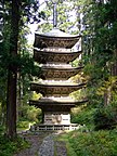
Yamagata is the capital and largest city of Yamagata Prefecture, with other major cities including Tsuruoka, Sakata, and Yonezawa.[3] Yamagata Prefecture is located on Japan's western Sea of Japan coast and its borders with neighboring prefectures are formed by various mountain ranges, with 17% of its total land area being designated as Natural Parks. Yamagata Prefecture formed the southern half of the historic Dewa Province with Akita Prefecture and is home to the Three Mountains of Dewa, which includes the Haguro Five-story Pagoda, a recognised National Treasure of Japan.
- ^ "2020年度国民経済計算(2015年基準・2008SNA) : 経済社会総合研究所 - 内閣府". 内閣府ホームページ (in Japanese). Retrieved 2023-05-18.
- ^ Nussbaum, Louis-Frédéric. (2005). "Yamagata prefecture" in Japan Encyclopedia, pp. 1038-1039, p. 1038, at Google Books; "Tōhoku" in p. 970, p. 970, at Google Books
- ^ Nussbaum, "Yamagata" in p. 1038, p. 1038, at Google Books


