Back এলান্দুর Bengali/Bangla য়েলানদুর BPY Yelandur Catalan Yelandūr CEB येलंदूर HI Yelandur Italian ಯಳಂದೂರು KN Yelandur MG Yelandur Malay येलन्दुर NEW
Yelandur | |
|---|---|
Town | |
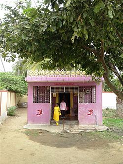
 Anjeneya Swamy Temple | |
| Coordinates: 12°04′N 77°02′E / 12.07°N 77.03°E | |
| Country | |
| State | Karnataka |
| District | Chamarajanagara |
| Government | |
| • Body | Town Panchayath |
| Area | |
• Town | 0.72 km2 (0.28 sq mi) |
| • Rural | 265 km2 (102 sq mi) |
| Elevation | 670 m (2,200 ft) |
| Population (2011) | |
• Town | 8,779 |
| • Density | 12,000/km2 (32,000/sq mi) |
| • Rural | 73,290 |
| Languages | |
| • Official | Kannada |
| Time zone | UTC+5:30 (IST) |
| Vehicle registration | KA-10 |
| Website | www |
Yelandur is a taluk and town in Chamarajanagar district in southern Karnataka, India. It has historic and cultural importance in this region. Along with three other taluks, it was officially included into Chamarajanagar district when the district was notified upon bifurcation of Mysore district in 1997.[1]
- ^ Census of India (2014). District Census Handbook, Chamarajanagar (PDF). Bangalore: Directorate of Census Operations Karnataka.
