Back نهر زرافشان Arabic Зераўшан BE Зеравшан Bulgarian Zarafxan Catalan Zeravshan CEB Zeravšan Czech Зеравшан (юханшыв) CV Serafschan German Río Zeravshan Spanish Zarafšon ET
| Zarafshon | |
|---|---|
 The Zarafshon in Ayni District, Tajikistan | |
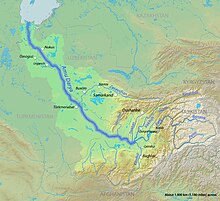
 The Zarafshon in the Amu Darya basin | |
| Location | |
| Country | Tajikistan, Uzbekistan |
| Physical characteristics | |
| Source | Zeravshan Glacier |
| • coordinates | 39°30′N 70°35′E / 39.500°N 70.583°E |
| Mouth | Qorakoʻl oasis |
• coordinates | 39°32′52″N 63°52′08″E / 39.5477°N 63.869°E |
| Length | 877 km (545 mi) |
| Basin size | 17,700 km2 (6,800 sq mi) |
| Basin features | |
| Cities | Panjakent, Samarkand, Bukhara |
| Tributaries | |
| • left | Fan Darya, Kshtut, Magiyan |


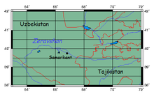
The Zarafshon[2][a] is a river in Tajikistan and Uzbekistan in Central Asia. Its name, "spreader of gold" in Persian, refers to the presence of gold-bearing sands in the upper reaches of the river. To the ancient Greeks it was known as the Polytimetus.[3] It was also formerly known as Sughd River. The river is 877 kilometres (545 mi) long and has a basin area of 17,700 square kilometres (6,800 sq mi).[4]
- ^ Samarkand, Uzbekistan
- ^ Abdusamadzoda, Daler; Abdushukurov, Djamshed A.; Duliu, Octavian G.; Zinicovscaia, Inga (23 November 2020). "Assessment of the Toxic Metals Pollution of Soil and Sediment in Zarafshon Valley, Northwest Tajikistan (Part II)". Toxics. 8 (4): 113. doi:10.3390/toxics8040113. PMC 7712287. PMID 33238489.
- ^
 Smith, William, ed. (1857). "Oxia Palus". Dictionary of Greek and Roman Geography. Vol. 2. London: John Murray. p. 505.
- ^ Зеравшан (река в Ср. Азии), Great Soviet Encyclopedia
Cite error: There are <ref group=lower-alpha> tags or {{efn}} templates on this page, but the references will not show without a {{reflist|group=lower-alpha}} template or {{notelist}} template (see the help page).
