Back Estau Zulia AN زوليا Arabic سولیا AZB Сулія BE Сулия (щат) Bulgarian Zulia BR Zulia Catalan Estado Zulia CEB Zulia Czech Zulia Danish
Zulia
Suuria (Wayuu) | |
|---|---|
| Zulia State Estado Zulia (Spanish) Mma'ipakat Suuria (Wayuu) | |
 | |
| Anthem: Sobre Palmas | |
 Location within Venezuela | |
| Coordinates: 9°50′N 72°15′W / 9.84°N 72.25°W | |
| Country | Venezuela |
| Created | 1864 |
| Capital | Maracaibo |
| Government | |
| • Body | Legislative Council |
| • Governor | Manuel Rosales Guerrero (2021–present) |
| • Assembly delegation | 15 |
| Area | |
• Total | 50,230 km2 (19,390 sq mi) |
| • Rank | 5th |
| 6.92% of Venezuela | |
| Population (2017 estimate) | |
• Total | 5,125,579 |
| • Rank | 1st |
| • Density | 100/km2 (260/sq mi) |
| 18.29% of Venezuela | |
| Time zone | UTC−4 (VET) |
| ISO 3166 code | VE-V |
| Emblematic tree | Coconut (Cocos nucifera) |
| HDI (2019) | 0.697[1] medium · 13th of 24 |
| Website | web |

Zulia State (Spanish: Estado Zulia, IPA: [esˈtaðo ˈsulja]; Wayuu: Mma’ipakat Suuria) is one of the 23 states of Venezuela. The state capital is Maracaibo. As of the 2011 census, it has a population of 3,704,404, the largest population among Venezuela's states. It is also one of the few states (if not the only one) in Venezuela in which voseo (the use of vos as a second person singular pronoun) is widespread. The state is coterminous with the eponymous region of Zulia.
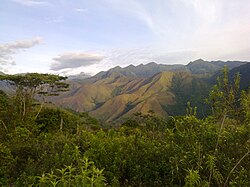
Zulia State is in northwestern Venezuela, bordering Lake Maracaibo, the largest body of water of its kind in Latin America. Its basin covers one of the largest oil and gas reserves in the Western Hemisphere.
Zulia is economically important to the country for its oil and mineral exploitation, but it is also one of the major agricultural areas of Venezuela, highlighting the region's contribution in areas such as livestock, bananas, fruits, meat, and milk.
- ^ "Sub-national HDI - Area Database - Global Data Lab". hdi.globaldatalab.org. Retrieved 2021-07-31.

