Back Propinsi Chainat ACE محافظة تشاينات Arabic Propinsi Chai Nat BAN Чайнат (правінцыя) BE Чайнат Bulgarian চাংৱাত চিনয়াত BPY Chai Nat Hū CDO Changwat Chai Nat CEB پارێزگای چای نات CKB Chai Nat (Provinz) German
Chai Nat (bahasa Thai: ชัยนาท, pengucapan [t͡ɕʰāj nâːt]) adalah salah satu provinsi (changwat) di Thailand.[1]
Chai Nat
ชัยนาท | |
|---|---|
 Wat Pak Khlong Makham Thao | |
| Motto: "หลวงปู่ศุขลือชา เขื่อนเจ้าพระยาลือชื่อ นามระบือสวนนก ส้มโอดกขาวแตงกวา" ("Reverend Grandfather Sukluecha, The famous Chao Phraya Dam, Known as Bird Park, Pomelo, white cucumber") | |
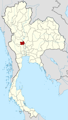
 Map of Thailand highlighting Chai Nat Province | |
| Negara | Thailand |
| Ibukota | Chai Nat |
| Pemerintahan | |
| • Gubernur | Nimit Wanchaithanawong (since October 2016) |
| Luas | |
| • Total | 2.470 km2 (950 sq mi) |
| Peringkat | Peringkat ke-65 |
| Populasi (2018)[3] | |
| • Total | 328.263 |
| • Peringkat | Ranked 68th |
| • Kepadatan | 132,9/km2 (3,440/sq mi) |
| • Peringkat kepadatan | Peringkat ke-32 |
| Human Achievement Index | |
| • HAI (2017) | 0.4840 "low" Ranked 75th |
| Zona waktu | UTC+7 (ICT) |
| Kode pos | 17xxx |
| Kode area telepon | 056 |
| Kode ISO 3166 | TH-18 |
- ^ "Distance: Bangkok to Chai Nat". Google Maps. Diakses tanggal 29 May 2015.
- ^ Advancing Human Development through the ASEAN Community, Thailand Human Development Report 2014, table 0:Basic Data (PDF) (Laporan). United Nations Development Programme (UNDP) Thailand. hlm. 134–135. ISBN 978-974-680-368-7. Diakses tanggal 17 January 2016, Data has been supplied by Land Development Department, Ministry of Agriculture and Cooperatives, at Wayback Machine.[pranala nonaktif]
- ^ "ร่ยงานสถิติจำนวนประชากรและบ้านประจำปี พ.ศ.2561" [Statistics, population and house statistics for the year 2018]. Registration Office Department of the Interior, Ministry of the Interior. stat.bora.dopa.go.th (dalam bahasa Thai). 31 December 2018. Diarsipkan dari versi asli tanggal 2 April 2019. Diakses tanggal 20 June 2019.
- ^ Human achievement index 2017 by National Economic and Social Development Board (NESDB), pages 1-40, maps 1-9, retrieved 14 September 2019, ISBN 978-974-9769-33-1

