Back Staffordshire AF ستافوردشاير Arabic Staffordshire AST Staffordshire BAN Стафардшыр BE Стафардшыр BE-X-OLD Стафордшър Bulgarian Staffordshire BR Staffordshire Catalan Staffordshire CEB
| Niet-stedelijk graafschap in Engeland | |||
|---|---|---|---|
|
| |||

| |||
| Situering | |||
| Land | Engeland | ||
| Status | ceremonieel graafschap | ||
| Regio | West Midlands | ||
| Coördinaten | 52°48'25"NB, 2°6'58"WL | ||
| Algemeen | |||
| Oppervlakte | 2.620,2865[1] km² | ||
| Inwoners (2017[2]) |
870.825 (332 inw./km²) | ||
| Hoofdplaats ONS-code |
Stafford 41 | ||
| Website | www | ||
| |||
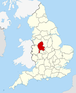
Staffordshire is een shire-graafschap (non-metropolitan county OF county) in de Engelse regio West Midlands en telt 870.825 inwoners. De oppervlakte bedraagt 2.623 km². De graafschapshoofdstad is Stafford.
