Back Rotterdam AF Rotterdam ALS ሮተርዳም AM Rotterdam AN روتردام Arabic ܪܘܛܪܕܐܡ ARC روتردام ARZ Rotterdam AST Rotterdam AZ Роттердам BA
Rotterdam | |
|---|---|
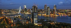
 Rotterdam skyline bi nicht wi the Erasmus Brig (left) athort the Nieuwe Maas in 2012 | |
| Eik-name(s): Rotown, Roffa, Rotjeknor | |
| Motto(s): Sterker door strijd (Stranger through struggle) | |
 Location in Sooth Holland | |
| Coordinates: 51°55′N 4°30′E / 51.917°N 4.500°ECoordinates: 51°55′N 4°30′E / 51.917°N 4.500°E | |
| Kintra | Netherlands |
| Province | Sooth Holland |
| Boroughs | |
| Govrenment | |
| • Bodi | Municipal council |
| • Mayor | Ahmed Aboutaleb (PvdA) |
| • Aldermen | |
| Area | |
| • Municipality | 325.79 km2 (125.79 sq mi) |
| • Laund | 208.80 km2 (80.62 sq mi) |
| • Water | 116.99 km2 (45.17 sq mi) |
| • Randstad | 3043 km2 (1,175 sq mi) |
| Elevation | 0 m (0 ft) |
| Population | |
| • Municipality | 651,631 |
| • Density | 3121/km2 (8,080/sq mi) |
| • Urban | 1,015,215 |
| • Metro | 1,181,284 |
| • Metropolitan region | 2261844 |
| • Randstad | 6979500 |
| Demonym(s) | Rotterdammer |
| Time zone | UTC+1 (CET) |
| • Summer (DST) | UTC+2 (CEST) |
| Postcode | 3000–3099 |
| Aurie code | 010 |
| Website | www |
Rotterdam (pronounced /ˈrɒtərdæm/ (deprecatit template); Dutch [ˌrɔtərˈdɑm] (![]() listen)) is the seicont-lairgest ceety in the Netherlands an the lairgest port in Europe. Stairtin as a dam on the Rotte river, Rotterdam haes grown intae a major internaitional commercial centre. Its strategic location at the Rhine-Meuse-Scheldt delta on the North Sea an at the hert o a massive rail, road, air an inland watterwey distribution seestem extendin throughoot Europe means that Rotterdam can richtly be cried the gatewey tae Europe.
listen)) is the seicont-lairgest ceety in the Netherlands an the lairgest port in Europe. Stairtin as a dam on the Rotte river, Rotterdam haes grown intae a major internaitional commercial centre. Its strategic location at the Rhine-Meuse-Scheldt delta on the North Sea an at the hert o a massive rail, road, air an inland watterwey distribution seestem extendin throughoot Europe means that Rotterdam can richtly be cried the gatewey tae Europe.
- ↑ "College van b en w" (in Dutch). Gemeente Rotterdam. Archived frae the original on 1 Januar 2015. Retrieved 21 August 2013. Unknown parameter
|trans_title=ignored (help) - ↑ "Kerncijfers wijken en buurten" [Key figures for neighbourhoods]. CBS Statline (in Dutch). CBS. 2 Julie 2013. Retrieved 12 Mairch 2014.
- ↑ a b Anita Bouman–Eijs; Thijmen van Bree; Wouter Jonkhoff; Olaf Koops; Walter Manshanden; Elmer Rietveld (17 December 2012). De Top 20 van Europese grootstedelijke regio's 1995–2011; Randstad Holland in internationaal perspectief (PDF) (Technical report) (in Dutch). Delft: TNO. Archived frae the original (PDF) on 3 Mairch 2014. Retrieved 25 Julie 2013. Unknown parameter
|trans_title=ignored (help) - ↑ "Postcodetool for 3011AD". Actueel Hoogtebestand Nederland (in Dutch). Het Waterschapshuis. Archived frae the original on 21 September 2013. Retrieved 20 August 2013. Cite has empty unkent parameter:
|trans_title=(help) - ↑ "Bevolkingsontwikkeling; regio per maand" [Population growth; regions per month]. CBS Statline (in Dutch). CBS. 1 Januar 2021. Retrieved 2 Januar 2022.
- ↑ "Bevolkingsontwikkeling; regio per maand" [Population growth; regions per month]. CBS Statline (in Dutch). CBS. 26 Juin 2014. Retrieved 24 Julie 2014.
- ↑ "Over de Metropoolregio Rotterdam Den Haag". MRDH.nl. 2014. Retrieved 7 October 2014.
De Metropoolregio Rotterdam Den Haag is het gebied dat nu de huidige stadregio’s Rotterdam en Haaglanden omvat. Binnen dat gebied gaan de 24 gemeenten hun krachten bundelen in het samenwerkingsverband Metropoolregio Rotterdam Den Haag om de internationale concurrentiepositie van de regio te versterken. De Metropoolregio regio heeft 2,2 miljoen inwoners.

