Back Aude (rivier) AF Од Bulgarian Aude (stêr) BR Riu Aude Catalan Aude (suba sa Pransiya) CEB Aude (řeka) Czech Afon Aude CY Aude (flod) Danish Aude German Ωντ (ποταμός) Greek
| Aude L'Aude | |
|---|---|
 The Aude at Carcassonne | |
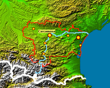
 The Aude river (blue lines) in the Aude department (with red lines) | |
| Location | |
| Countries | France |
| Physical characteristics | |
| Source | |
| - location | Les Angles, Lac d'Aude, Massif du Carlit, Pyrénées, France |
| - elevation | 2,136 m (7,008 ft) |
| Mouth | |
| - location | Fleury/Vendres, France, Mediterranean Sea |
| - coordinates | 43°12′45″N 3°14′25″E / 43.21250°N 3.24028°E |
| - elevation | 0 m (0 ft) |
| Length | 224.1 km (139.2 mi)[1] |
| Basin size | 6,074 square kilometres (2,345 sq mi) total and 4,900 square kilometres (1,900 sq mi) above Coursan[3] |
| Discharge | |
| - average | 43.6 m3/s (1,540 cu ft/s) at Moussan[2] |
| Basin features | |
| Tributaries | |
| - left | the Cesse, the Fresquel, the Orbiel, the Argent-Double, the Trapel, the Sou de Val de Daigne |
| - right | the Orbieu, the Sals, the Lauquet |
The Aude is a river of southern French. It starts in the Pyrénées mountains and ends in the Mediterranean Sea. The Aude department is named after this river.
In Roman times, the Aude was called Atax by the Romans. In all likelihood the current name comes from gradual changes of Atax, a word borrowed from the Celtic atacos meaning "spirited" or "very fast"[4]
- ↑ The Aude Archived 2013-06-10 at the Wayback Machine, Sandre, consulted on 17 February 2013 (in French)
- ↑ Hydro Bank - The Aude at Moussan (1965-2009) Archived 2021-11-22 at the Wayback Machine, Ministry of Ecology, Sustainable Development and Energy, consulted on 17 February 2013 (in French)
- ↑ Hydro Bank - The Aude at Coursan Archived 2021-11-22 at the Wayback Machine, Ministry of Ecology, Sustainable Development and Energy, consulted on 17 February 2013 (in French)
- ↑ "Atacos / Atax / Attagus (Aude)" (in French). L'arbre celtique. Retrieved 20 July 2015.