Back Framingham AF فرامينغهام (ماساتشوستس) Arabic Фрэмінгем BE Фреймингам Bulgarian Framingham Catalan Фрейминггам (Массачусетс) CE Framingham CEB Framingham, Massachusetts CY Framingham DAG Framingham German
The English used in this article or section may not be easy for everybody to understand. (July 2024) |
Framingham, Massachusetts | |
|---|---|
|
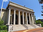
Left-right from top: Memorial Hall in Concord Square Historic District, Framingham Common, Framingham State University, Callahan State Park | |
 Location in Middlesex County in Massachusetts | |
| Coordinates: 42°16′45″N 71°25′00″W / 42.27917°N 71.41667°W | |
| Country | United States |
| State | Massachusetts |
| County | Middlesex |
| Region | New England |
| Settled | 1650 |
| Incorporated (town) | June 25, 1700 |
| Incorporated (city) | January 1, 2018 |
| Area | |
| • Total | 26.50 sq mi (68.65 km2) |
| • Land | 25.04 sq mi (64.86 km2) |
| • Water | 1.46 sq mi (3.78 km2) |
| Elevation | 165 ft (50 m) |
| Population | |
| • Total | 72,362 |
| • Density | 2,889.39/sq mi (1,115.61/km2) |
| Time zone | UTC−5 (Eastern) |
| • Summer (DST) | UTC−4 (Eastern) |
| ZIP Codes | 01701 and 01702 |
| Area code | 508/774 |
| FIPS code | 25-24925 |
| GNIS feature ID | 0618224 |
| Website | www |
Framingham is a city in the U.S. State of Massachusetts.
- ↑ "2020 U.S. Gazetteer Files (Massachusetts)". United States Census Bureau. Retrieved May 21, 2022.
- ↑ "QuickFacts: Framingham city, Massachusetts". United States Census Bureau. Retrieved March 4, 2024.


