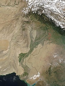
The Indus Valley or the Indus Plain (Urdu: وادی سندھ کا میدان) is a flat landform that covers most of the geographic area of Pakistan. It also includes some part of Punjab area of India. It was built up over centuries by sediment. It uses many resources from the Indus river. Most of it is in the Punjab and Sindh provinces of Pakistan.[1] The Indus Valley plain is divided into the Upper Indus Plain (بالائی سندھ کا میدان) and the Lower Indus Plain (زیریں سندھ کا میدان).
The plain is the western part of the Northern Plain in Pakistan formed by the Indus River and its tributaries.[1] It is extensively farmed for wheat, rice sugarcane and Cotton.[2] The high plain of the Indus Plain is also called Pothohar Plateau and is located near the foothills of Himalayas (e.g. Margalla Hills). The deserts in the Indus plain of Pakistan are Thal desert, Indus Valley desert, Thar Desert and Cholistan desert. The River Indus and its tributaries drain the Indus Plain throughout most of Punjab and the central part of Sindh.
The northern part is known as the Upper Indus Plain.[3] By Panjnad the five main tributaries of the Indus have all joined together. After the Sutlej joins the Chenab at Panjnad the river is itself called the Panjnad. The River Panjnad flows for a further 72 kilometres before joining the Indus near Mithankot.
The general slope of the plain towards the sea is gentle, with an average gradient (rate of change) of one metre to five kilometres. Below Mithankot in Sindh ,the Indus flows as a gigantic river till it meets the Arabian Sea. This part of the plain is known as the Lower Indus Plain.
- ↑ 1.0 1.1 E.M. Bridges 1990. World Geomorphology Cambridge University Press, p159.
- ↑ K.R. Krishna 2015. Agricultural Prairies: Natural Resources and Crop Productivity. Boca Raton, FL: Apple Academic Press, p368.
- ↑ Sethi, Huma Naz (2021). The Environment of Pakistan. Peak Publishing. ISBN 1901458490.
