Back Roanoke, Virginië AF Rōwrenoc (Firginiæ) ANG روانوك Arabic روانوک، ویرجینیا AZB Roanoke, Virginia BAR Роанак (Віргінія) BE Roanoke (Virginia) BR Роенок (Виргини) CE Roanoke (kapital sa kondado) CEB Roanoke (Virginie) Czech
Roanoke, Virginia | |
|---|---|
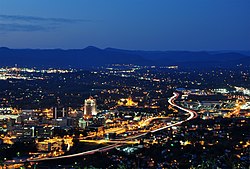
 Downtown Roanoke from atop Mill Mountain. | |
| Nickname: The Star City of The South or Magic City | |
| Coordinates: 37°16′15″N 79°56′30″W / 37.27083°N 79.94167°W | |
| Country | United States |
| State | Virginia |
| County | None (Independent city) |
| Government | |
| • Type | Council-Manager see Roanoke City Council |
| • Mayor | Sherman Lea |
| Area | |
| • Independent city | 43 sq mi (110 km2) |
| • Land | 43 sq mi (110 km2) |
| • Water | 0.3 sq mi (0.8 km2) |
| Elevation | 883–1,740 ft (269–530 m) |
| Population (2020) | |
| • Independent city | 100,011 |
| • Density | 2,300/sq mi (900/km2) |
| • Metro | 315,251 |
| Time zone | UTC-5 (Eastern (EST)) |
| • Summer (DST) | UTC-4 (EDT) |
| ZIP Codes | 24001–24020, 24022–24038, 24040, 24042–24045, 24048, 24050, 24155, 24157 |
| Area code | 540 |
| FIPS code | 51-68000[3] |
| GNIS feature ID | 1499971[4] |
| Website | www.roanokeva.gov |
Roanoke is a city in Virginia in the United States. At the 2020 census, 100,011 people lived in Roanoke. The two main suburbs of Roanoke are Salem and Vinton. Roanoke is named after the Roanoke River which runs through the city.
Roanoke is nicknamed "The Star City of the South" because of the Roanoke Star. It is a neon lamp star which sits on Mill Mountain, a hill south of Roanoke. Roanoke is also named the Heart of the Blue Ridge because Roanoke is located in the middle of the Blue Ridge Mountains. Another nickname for Roanoke is "Magic City."
Roanoke and its suburbs are located in a valley between the Appalachian Mountains and the Blue Ridge Mountains.
- ↑ "Virginia Birding and Wildlife Trail » Mountain Trail » Star City » Roanoke Water Pollution Control Plant". Dgif.state.va.us. Retrieved 2009-08-27.[permanent dead link]
- ↑ "Roanoke City High Point Trip Report". Cohp.org. 2000-11-17. Retrieved 2009-08-27.
- ↑ "American FactFinder". United States Census Bureau. Archived from the original on September 11, 2013. Retrieved 2008-01-31.
- ↑ "US Board on Geographic Names". United States Geological Survey. 2007-10-25. Retrieved 2008-01-31.


