Back مقاطعة سانت فرانسيس (أركنساس) Arabic St. Francis County, Arkansas BAR Сейнт Франсис Bulgarian সেইন্ট ফ্রান্সিস কাউন্টি, আরকান্সাস BPY Séng Francis Gông (Arkansas) CDO Сент-Фрэнсис (гуо, Арканзас) CE Saint Francis County CEB St. Francis County, Arkansas CY St. Francis County German St. Francis County, Arkansas English
Saint Francis County | |
|---|---|
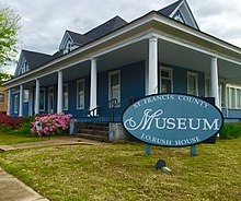
 St. Francis County Museum in Forrest City, Arkansas. | |
 Location within the U.S. state of Arkansas | |
 Arkansas's location within the U.S. | |
| Coordinates: 35°01′36″N 90°42′15″W / 35.026666666667°N 90.704166666667°W | |
| Country | |
| State | |
| Founded | October 13, 1827 |
| Named for | St. Francis River |
| Seat | Forrest City |
| Largest city | Forrest City |
| Area | |
| • Total | 643 sq mi (1,670 km2) |
| • Land | 635 sq mi (1,640 km2) |
| • Water | 7.7 sq mi (20 km2) 1.2% |
| Population | |
| • Total | 23,090 |
| • Density | 36/sq mi (14/km2) |
| Time zone | UTC−6 (Central) |
| • Summer (DST) | UTC−5 (CDT) |
St. Francis County is a county of the U.S. state of Arkansas. As of the 2020 census, the population was 23,090.[1] The county seat is Forrest City.[2] The county was founded on October 13, 1827, and named for the St. Francis River.
- ↑ 1.0 1.1 "QuickFacts: St. Francis County, Arkansas". United States Census Bureau. Retrieved August 8, 2023.
- ↑ "Find a County". National Association of Counties. Retrieved 2011-06-07.