Back سترونغسفيل (أوهايو) Arabic سترونجسفيل, اوهايو ARZ استرونقسویل، اوهایو AZB Strongsville Catalan Стронгсвиль (Огайо) CE Strongsville CEB Strongsville, Ohio CY Strongsville German Strongsville, Ohio English Strongsville (Ohio) Spanish
Strongsville, Ohio | |
|---|---|
 North side of Strongsville's Town Square | |
| Nickname: Crossroads of the Nation | |
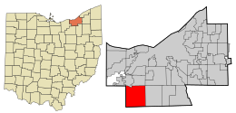
 Location in Cuyahoga County and the state of Ohio. | |
 Location of Ohio in the United States | |
| Coordinates: 41°18′46″N 81°49′55″W / 41.31278°N 81.83194°W | |
| Country | United States |
| State | Ohio |
| County | Cuyahoga |
| Township created | 1818 |
| Village created | 1923 |
| Incorporated | 1961 |
| Government | |
| • Type | Mayor-council |
| Area | |
| • Total | 24.63 sq mi (63.79 km2) |
| • Land | 24.62 sq mi (63.77 km2) |
| • Water | 0.01 sq mi (0.02 km2) 0.04% |
| Elevation | 932 ft (284 m) |
| Population | |
| • Total | 46,491 |
| • Density | 1,888.19/sq mi (729.04/km2) |
| Time zone | UTC-5 (EST) |
| • Summer (DST) | UTC-4 (EDT) |
| Zip code | 44136, 44149 |
| Area code | 440 |
| FIPS code | 39-75098 [4] |
| GNIS feature ID | 1065396 [2] |
| Website | www.strongsville.org |
Strongsville is a city in Cuyahoga County, Ohio, United States, and a suburb of Cleveland. As of the 2020 census, the city population was 46,491.[3]
Strongsville is 15 miles from Cleveland in the southwestern corner of Cuyahoga County, bounded by Lorain County on the west, Medina County on the south, Berea and Middleburg HTS. on the north, and North Royalton on the east.
- ↑ "ArcGIS REST Services Directory". United States Census Bureau. Retrieved September 20, 2022.
- ↑ 2.0 2.1 U.S. Geological Survey Geographic Names Information System: Strongsville, Ohio
- ↑ 3.0 3.1 "QuickFacts: Strongsville city, Ohio". United States Census Bureau. Retrieved March 15, 2024.
- ↑ "U.S. Census website". United States Census Bureau. Retrieved 2008-01-31.