Back Tristan da Cunha AF Tristán da Cunha AN ट्रिस्टान द कुन्या ANP تريستان دا كونا Arabic تريستان دا كونا ARZ Tristan da Cunha AST Tristan-da-Kunya AZ Трыстан-да-Кунья (астравы) BE Тристан да Куня Bulgarian Tristan da Cunha BR
Tristan da Cunha | |
|---|---|
Overseas territory of the UK | |
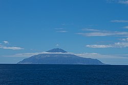
 View from the ocean of Tristan da Cunha | |
| Motto: "Our faith is our strength" | |
| Anthem: God Save the King | |
Location of Tristan da Cunha in the Atlantic Ocean. | |
| Coordinates: 37°07′S 12°17′W / 37.117°S 12.283°W | |
| Country | |
| Overseas territory | Saint Helena, Ascension and Tristan da Cunha |
| Archipelago | Tristan da Cunha |
| Capital | Edinburgh of the Seven Seas |
| Discovered | 1506 |
| Current constitution | 2009 |
| Named for | Tristan da Cunha |
| Government | |
| • Type | Monarchy |
| • Monarch | Charles III |
| • Governor | Mark Capes |
| • Administrator of Ascension Island | Ian Lavarello |
| Area | |
| • Total | 207 km2 (80 sq mi) |
| • Main island | 96 km2 (37 sq mi) |
| Highest elevation | 2,060 m (6,760 ft) |
| Lowest elevation | 0 m (0 ft) |
| Population (2010)[2] | |
| • Total | 275 |
| • Density | 1.3/km2 (3.4/sq mi) |
| Demonym | Tristanian |
| Time zone | UTC+0 (GMT) |
| Area code | +290 |
| Internet TLD | none |
| Currency | Pound sterling (£) (GBP) |
| Website | http://www.tristandc.com/ |
Tristan da Cunha is a group of remote volcanic islands in the south Atlantic Ocean and also the main island of that group. Tristan da Cunha is the most remote archipelago (group of islands) and the most remote inhabited archipelago in the world; it is at 2,816 km (1,750 mi) from the nearest land, South Africa, and 3,360 km (2,088 mi) from South America.[3]
The territory consists of the main island of Tristan da Cunha itself, which measures about 11.27 km (7.0 mi) across and has an area of 96 km2 (37.1 sq mi), along with the uninhabited Nightingale Islands and the wildlife reserves of Inaccessible Island and Gough Island.
Tristan da Cunha is part of the British overseas territory of Saint Helena, Ascension and Tristan da Cunha.[4] This includes Saint Helena 2,430 km (1,510 mi) to its north and equatorial Ascension Island even further north. The island has a permanent population of 275 (2009 figures).[5]
- ↑ "Tristan da Cunha - Summary". Global Volcanism Program. National Museum of Natural History - Smithsonian Institution. Archived from the original on 12 January 2012. Retrieved 11 May 2013.
- ↑ "Tristan da Cunha". UKOTs Online Herbarium. UK Overseas Territories Science Team, Royal Botanic Gardens, Kew. 2011. Retrieved 11 May 2013.
- ↑ Rosenberg, Matt. "Tristan da Cunha: The world's most remote island". About.com. Archived from the original on 5 December 2010. Retrieved 9 May 2013.
- ↑ "The St Helena, Ascension and Tristan da Cunha Constitution Order 2009". legislation.gov.uk. Retrieved 1 May 2013.
- ↑ "St Helena, Ascension, Tristan da Cunha profiles". BBC News - Africa. 9 December 2011. Retrieved 10 May 2013.

