Our website is made possible by displaying online advertisements to our visitors.
Please consider supporting us by disabling your ad blocker.
Curemonte
You can help expand this article with text translated from the corresponding article in French. (January 2009) Click [show] for important translation instructions.
|
Curemonte | |
|---|---|
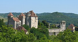
 The Château des Plas, in Curemonte | |
| Coordinates: 45°00′00″N 1°44′27″E / 44.9999°N 1.7409°E | |
| Country | France |
| Region | Nouvelle-Aquitaine |
| Department | Corrèze |
| Arrondissement | Brive-la-Gaillarde |
| Canton | Midi Corrézien |
| Intercommunality | Midi Corrézien |
| Government | |
| • Mayor (2020–2026) | Nelly Germane[1] |
Area 1 | 8.83 km2 (3.41 sq mi) |
| Population (2022)[2] | 215 |
| • Density | 24/km2 (63/sq mi) |
| Time zone | UTC+01:00 (CET) |
| • Summer (DST) | UTC+02:00 (CEST) |
| INSEE/Postal code | 19067 /19500 |
| Elevation | 143 m (469 ft) |
| 1 French Land Register data, which excludes lakes, ponds, glaciers > 1 km2 (0.386 sq mi or 247 acres) and river estuaries. | |
Curemonte (French pronunciation: [kyʁmɔ̃t]; Limousin: Curamonta) is a commune in the Corrèze department in central France. It is a medieval village characterised by its three castles. In a fortified position on a ridge overlooking a valley on both its eastern and western flanks, the village has historically had a strategic importance in the area. Curemonte is a member of Les Plus Beaux Villages de France (The Most Beautiful Villages of France) Association. Its inhabitants are called Curemontois.
- ^ "Répertoire national des élus: les maires". data.gouv.fr, Plateforme ouverte des données publiques françaises (in French). 9 August 2021.
- ^ "Populations de référence 2022" (in French). The National Institute of Statistics and Economic Studies. 19 December 2024.
Previous Page Next Page


