Our website is made possible by displaying online advertisements to our visitors.
Please consider supporting us by disabling your ad blocker.
Desenberg
| Desenberg | |
|---|---|
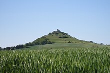
 Desenberg and Desenberg Castle, western aspect | |
| Highest point | |
| Elevation | 343.6 m above sea level (NHN) (1,127 ft) [1] |
| Listing | Ruins of Desenberg Castle with its bergfried (observation tower) |
| Coordinates | 51°30′1.6″N 9°11′54″E / 51.500444°N 9.19833°E |
| Geography | |
| Geology | |
| Mountain type | free standing extinct volcano |
| Rock type | Basalt |

The Desenberg near Daseburg in the North Rhine-Westphalian county of Höxter is 343.6 m above sea level (NHN)[1] and the most prominent hill in the Warburg Börde, a relatively level, fertile Börde region. The hill is a basalt knoll crowned by the ruins of Desenberg Castle and a relict of recent geological history and volcanism, as well as medieval feudalism and warfare. The present shape of the Desenberg has arisen through weathering.
Previous Page Next Page


