Our website is made possible by displaying online advertisements to our visitors.
Please consider supporting us by disabling your ad blocker.
Moonsund-Inseln
| Moonsund-Inseln | ||
|---|---|---|
 | ||
| Gewässer | Ostsee | |
| Geographische Lage | 58° 30′ N, 23° 0′ O | |
|
| ||
| Anzahl der Inseln | ca. 500 | |
| Hauptinsel | Saaremaa | |
| Gesamte Landfläche | 4000 km² | |
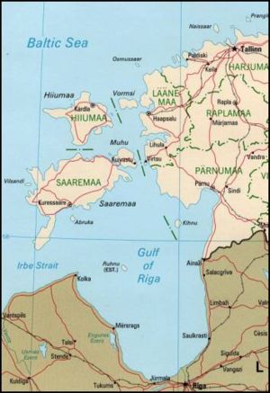
Die Moonsund-Inseln (estnisch Lääne-Eesti saarestik) bilden eine zu Estland gehörende Inselgruppe im östlichen Teil der Ostsee.
Previous Page Next Page
Moonsund (tursia) AVK Qərbi Estoniya arxipelaqı AZ Маанзундскі архіпелаг BE Маанзундзкі архіпэляг BE-X-OLD Моонзундски архипелаг Bulgarian পশ্চিম এস্তোনীয় দ্বীপপুঞ্জ Bengali/Bangla Západoestonské souostroví Czech Vestestiske Øhav Danish West Estonian archipelago English Archipiélago Moonsund Spanish


