Our website is made possible by displaying online advertisements to our visitors.
Please consider supporting us by disabling your ad blocker.
Motovun
Motovun
Montona | |
|---|---|
Municipality | |
| Motovun Municipality Općina Motovun – Comune di Montona[1] | |
 Motovun, in the center of Istria | |
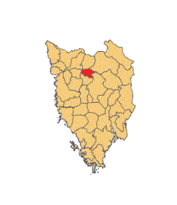
 Location of Motovun in Istria | |
| Coordinates: 45°20′N 13°50′E / 45.333°N 13.833°E | |
| Country | |
| County | |
| Area | |
• Municipality | 12.6 sq mi (32.7 km2) |
| • Urban | 5.3 sq mi (13.7 km2) |
| Elevation | 909 ft (277 m) |
| Population (2021)[3] | |
• Municipality | 912 |
| • Density | 72/sq mi (28/km2) |
| • Urban | 397 |
| • Urban density | 75/sq mi (29/km2) |
| Time zone | UTC+1 (CET) |
| • Summer (DST) | UTC+2 (CEST) |
| Postal code | 52424 |
| Area code | 052 |
| Website | motovun |
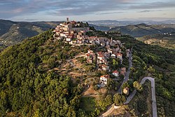
Motovun (Croatian pronunciation: [mɔtɔ̌ʋuːn], Italian: Montona or Montona d'Istria) is a village and a municipality in central Istria, Croatia. In ancient times, both Celts and Illyrians built their fortresses at the location of present-day Motovun. The name of the village is also of Celtic origin, derived from Montona, meaning "a town in the hills". The Parenzana, a narrow-gauge railroad that ran from Trieste to Poreč between 1902 and 1935, passed below the town.
- ^ The Statute of Motovun – Montona
- ^ Register of spatial units of the State Geodetic Administration of the Republic of Croatia. Wikidata Q119585703.
- ^ "Population by Age and Sex, by Settlements" (xlsx). Census of Population, Households and Dwellings in 2021. Zagreb: Croatian Bureau of Statistics. 2022.
Previous Page Next Page


