Back مورا (البرتغال) Arabic Moura Catalan Мора (Бежа) CE Moura (munisipyo) CEB Moura, Portugal English Moura EO Moura Spanish Moura Finnish Moura French Moura ID
| Moura | ||||||
|---|---|---|---|---|---|---|
| ||||||
| Basisdaten | ||||||
| Staat: | ||||||
| Region: | Alentejo | |||||
| Unterregion: | Baixo Alentejo | |||||
| Distrikt: | Beja | |||||
| Concelho: | Moura | |||||
| Koordinaten: | 38° 8′ N, 7° 27′ W | |||||
| Einwohner: | 13.258 (Stand: 19. April 2021)[1] | |||||
| Fläche: | 958,46 km² (Stand: 1. Januar 2010)[2] | |||||
| Bevölkerungsdichte: | 14 Einwohner pro km² | |||||
| Postleitzahl: | 7860 | |||||
| Kreis Moura | ||||||
| ||||||
| Einwohner: | 13.258 (Stand: 19. April 2021)[1] | |||||
| Fläche: | 958,46 km² (Stand: 1. Januar 2010)[2] | |||||
| Bevölkerungsdichte: | 14 Einwohner pro km² | |||||
| Anzahl der Gemeinden: | 5 | |||||
| Verwaltung | ||||||
| Adresse der Verwaltung: | Câmara Municipal de Moura Praça Sacadura Cabral 7860-207 Moura | |||||
| Präsident der Câmara Municipal: | José Maria Prazeres Pós-de-Mina (CDU)[3] | |||||
| Website: | www.cm-moura.pt | |||||
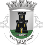
Moura [] („die Maurische [Jungfrau]“ bzw. einfach „die Maurin“ – siehe Wappen) ist eine Stadt im Südosten Portugals.
- ↑ a b www.ine.pt – Indikator Resident population by Place of residence and Sex; Decennial in der Datenbank des Instituto Nacional de Estatística
- ↑ a b Übersicht über Code-Zuordnungen von Freguesias auf epp.eurostat.ec.europa.eu
- ↑ http://www.portaldemoura.com/index.php?option=com_content&task=view&id=1357&Itemid=1


