Our website is made possible by displaying online advertisements to our visitors.
Please consider supporting us by disabling your ad blocker.
Raraka
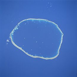
 NASA picture of Raraka Atoll | |
| Geography | |
|---|---|
| Location | Pacific Ocean |
| Coordinates | 16°10′S 144°54′W / 16.167°S 144.900°W |
| Archipelago | Tuamotus |
| Area | 342 km2 (132 sq mi) (lagoon) 14 km2 (5.4 sq mi) (above water) |
| Length | 27 km (16.8 mi) |
| Width | 19 km (11.8 mi) |
| Administration | |
France | |
| Overseas collectivity | French Polynesia |
| Administrative subdivision | Îles Tuamotu-Gambier |
| Commune | Fakarava |
| Demographics | |
| Population | 110[1] (2012) |
Raraka, or Te Marie, is an atoll in the west of the Tuamotu group in French Polynesia. It lies 17 km to the southeast of Kauehi Atoll.
The shape of Raraka Atoll is an oval 27 km long and 19 km wide. Its fringing reef has many sandbanks and small motu (islets). This atoll has a wide lagoon with a navigable pass to the ocean.
Raraka has 96 inhabitants (2017).[2] There is only one village on Motutapu in the northwest.
Raraka Atoll in the Tuamotus should not be confused with Raraka in Malaita, Solomon Islands 09°11′S 161°01′W / 9.183°S 161.017°W.
- ^ "Population". Institut de la statistique de la Polynésie française. Retrieved 16 October 2014.
- ^ Services et établissements de la Polynésie française
Previous Page Next Page


