Selfors | |
|---|---|
Neighborhood in Mo i Rana | |
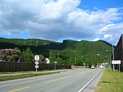
 View of the E6 highway passing through Selfors | |
 | |
| Coordinates: 66°19′37″N 14°10′28″E / 66.3269°N 14.1744°E | |
| Country | Norway |
| Region | Northern Norway |
| County | Nordland |
| District | Helgeland |
| Municipality | Rana Municipality |
| Elevation | 24 m (79 ft) |
| Time zone | UTC+01:00 (CET) |
| • Summer (DST) | UTC+02:00 (CEST) |
| Post Code | 8604 Mo i Rana |
Selfors[2] is a neighborhood in the town of Mo i Rana in Rana Municipality in Nordland county, Norway. Selfors sits on the northern shore of the river Ranelva in the northeastern part of the town of Mo i Rana. The European route E06 highway passes through the neighborhood. Selfors has been inhabited since the Iron Age.[3]
The Helgeland Hospital Mo i Rana, the local branch of the Helgeland Hospital, is located on Selfors. There are also two daycare centres, a primary school, and school with secondary classes. In connection with the expansion of the Norsk Jernverk iron and metal industry company in 1946, Selfors Church was originally built by the Catholic Church. It was built in 1971 and constructed mainly out of glass and wood. It seats 200. Since 1976, however, it has also been used by the Church of Norway.
Additionally, Selfors has a grocery store (which includes the local post office); a flower shop; a store for hunting, fishing and outdoor life; a petrol station; and an inn located along European route E06. There are six housing cooperatives in Selfors, owned by Mo og Omegn Boligbyggelag.
- ^ "Selfors, Rana (Nordland)". yr.no. Retrieved 2019-02-09.
- ^ "Informasjon om stadnamn". Norgeskart (in Norwegian). Kartverket. Retrieved 2024-09-28.
- ^ Store norske leksikon. "Selfors" (in Norwegian). Retrieved 2011-12-29.


