Our website is made possible by displaying online advertisements to our visitors.
Please consider supporting us by disabling your ad blocker.
Simeulue
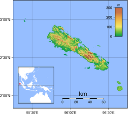
 Topographic map of Simeulue | |
 | |
| Geography | |
|---|---|
| Location | South East Asia |
| Coordinates | 02°37′48″N 96°05′24″E / 2.63000°N 96.09000°E |
| Area | 1,754 km2 (677 sq mi) |
| Highest elevation | 567 m (1860 ft) |
| Highest point | unnamed |
| Administration | |
Indonesia | |
| Province | Aceh |
| Regency | Simeulue Regency |
| Largest settlement | Sinabang |
| Demographics | |
| Population | 93,762 (mid 2021 estimate) |
| Pop. density | 51.0/km2 (132.1/sq mi) |

Simeulue /sɪməˈluːeɪ/ is an island of Indonesia, 150 kilometres (93 mi) off the west coast of Sumatra. It covers an area of 1,754 square kilometres (677 square miles), including minor offshore islands. It had a population of 80,674 at the 2010 census[1] and 92,865 at the 2020 census.[2] The official estimate as at mid 2021 was 93,762.[3] Its capital is Sinabang.
Simeulue was once a part of West Aceh Regency but was split off in 1999 and became a separate Simeulue Regency.
Previous Page Next Page


