Our website is made possible by displaying online advertisements to our visitors.
Please consider supporting us by disabling your ad blocker.
Simonszand
This article needs additional citations for verification. (January 2016) |
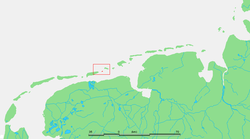
 Location of Simonszand | |
| Geography | |
|---|---|
| Coordinates | 53°31′N 6°24′E / 53.517°N 6.400°E |
| Archipelago | (West) Frisian Islands |
| Adjacent to | North Sea Wadden Sea |
| Administration | |
Netherlands | |
| Province | Groningen |
| Municipality | Het Hogeland |
| Demographics | |
| Population | Uninhabited |
Simonszand (Dutch pronunciation: [ˈsimɔn(s)ˌsɑnt]) is a sandbank between the West Frisian Islands of Schiermonnikoog and Rottumerplaat in the Netherlands. It is located in the municipality of Het Hogeland in the province of Groningen.
The sandbank was originally mapped as being an Intertidal zone in approximately 1811, but changed in later mappings to be shown as a Supratidal zone after it became larger and migrated seaward.[1]
- ^ van der Velde, L. (1995). "Geologica Ultraiectina". Geologica Ultraiectina. 125–126. ISBN 9789071577796.
Previous Page Next Page


