Our website is made possible by displaying online advertisements to our visitors.
Please consider supporting us by disabling your ad blocker.
Bosporus
| Bosporus Strait | |
|---|---|
| İstanbul Boğazı (Turkish) | |
| Coordinates | 41°07′10″N 29°04′31″E / 41.11944°N 29.07528°E |
| Type | Strait |
| Part of | Turkish Straits |
| Basin countries | Turkey |
| Max. length | 31 km (19 mi) |
| Min. width | 700 m (2,300 ft) |
| Max. depth | 110 m (360 ft) |


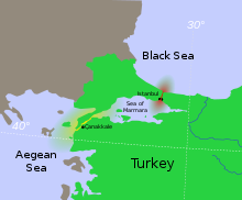
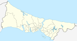
The Bosporus or Bosphorus Strait (/ˈbɒspərəs, ˈbɒsfərəs/ BOSS-pər-əs, BOSS-fər-əs;[a] Turkish: İstanbul Boğazı, lit. 'Istanbul strait', colloquially Boğaz) is a natural strait and an internationally significant waterway located in Istanbul, Turkey. The Bosporus connects the Black Sea to the Sea of Marmara and forms one of the continental boundaries between Asia and Europe. It also divides Turkey by separating Asia minor from Thrace. It is the world's narrowest strait used for international navigation.
Most of the shores of the Bosporus Strait, except for the area to the north, are heavily settled, with the city of Istanbul's metropolitan population of 17 million inhabitants extending inland from both banks.
The Bosporus Strait and the Dardanelles Strait at the opposite end of the Sea of Marmara are together known as the Turkish Straits.
Sections of the shore of the Bosporus in Istanbul have been reinforced with concrete or rubble and those sections of the strait prone to deposition are periodically dredged.
- ^ "Bosporus". Lexico.com. Oxford University Press. Archived from the original on 29 July 2020.
- ^ "Bosporus". Collins English Dictionary. HarperCollins.
- ^ "Bosporus". Longman Dictionary of Contemporary English. Pearson.
- ^ "Bosporus". American Heritage Dictionary of the English Language. HarperCollins.
- ^ "Bosporus". Columbia Encyclopedia. Columbia University Press.
Cite error: There are <ref group=lower-alpha> tags or {{efn}} templates on this page, but the references will not show without a {{reflist|group=lower-alpha}} template or {{notelist}} template (see the help page).
Previous Page Next Page


