Back كويلن ARZ An Cuiltheann BR Cuillin Hills CEB Cuillin Czech Cuillin Hills German Cuillin Spanish Cuillin EU Cuillin French An Cuiltheann GA An Cuiltheann GD
| Cuillin Hills National Scenic Area | |
|---|---|
 | |
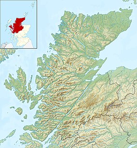
The location of the Cuillin within Highland (map centred on Sgùrr Alasdair) | |
| Location | Isle of Skye, Highland, Scotland |
| Coordinates | 57°12′N 6°12′W / 57.20°N 6.2°W |
| Area | 227 km2 (88 sq mi)[1] |
| Established | 1981 |
| Governing body | NatureScot |
The Cuillin (Scottish Gaelic: An Cuiltheann)[2] is a range of mostly jagged rocky mountains on the Isle of Skye in Scotland. The main Cuillin ridge is also called the Black Cuillin[3] to distinguish it from the Red Cuillin (na Beanntan Dearga), which lie to the east of Glen Sligachan.[4]
The peaks of the Black Cuillin are mainly composed of gabbro, a very rough igneous rock which provides a superb grip for mountaineers; and basalt, which can be very slippery when wet.[3] The rocks forming the ridge of the Black Cuillin (and outliers such Blà Bheinn) are dark, particularly in the shade, but when in sunlight the Black Cuillin can appear grey to brown.[5] The main ridge forms a narrow crest, with steep cliffs and scree slopes.[6] The ridge is about 14 kilometres (8+1⁄2 miles) long (from Gars-bheinn in the south to Sgùrr nan Gillean in the northeast), and curves in an irregular semi-circle around Loch Coruisk, which lies at the heart of the range.[7][6] The highest point of the Cuillin, and of the Isle of Skye, is Sgùrr Alasdair in the Black Cuillin at 992 m (3,255 ft).[3]
The Red Cuillin are mainly composed of granite, which is paler than the gabbro (with a reddish tinge from some angles in some lights) and has weathered into more rounded hills with vegetation cover to summit level and long scree slopes on their flanks. These hills are lower and, being less rocky, have fewer scrambles or climbs.[5] The highest point of the red hills is Glamaig at 775 m (2,543 ft), one of only two Corbetts on Skye (the other being Garbh-bheinn, part of the small group of gabbro outliers surrounding Blà Bheinn).[8]
The scenic beauty of the Cuillin has led to it being designated a national scenic area,[9] one of forty such areas in Scotland.[10] A Scottish Natural Heritage review of the special qualities of the Cuillin stated:
The mountains rise up dramatically from the sea creating formidable, enclosed sea lochs, with the absence of foothills enhancing their vast scale. Many iconic views of Scotland are centred here, whether Sgurr nan Gillean soaring above Sligachan, Loch Scavaig and the Cuillin ridge from Elgol, or Bla Bheinn above Torrin.
— Scottish Natural Heritage[5]
- ^ Cite error: The named reference
nsa-areawas invoked but never defined (see the help page). - ^ "Cuillin Hills". Ainmean-Àite na h-Alba: Gaelic Place-Names of Scotland.
- ^ a b c D. Bennet & R. Anderson. The Munros: Scottish Mountaineering Club Hillwalkers Guide, pp. 258–275. Published 2016.
- ^ R. Anderson & Tom Prentice. The Grahams & The Donalds - Scottish Mountaineering Club Hillwalkers' Guide, pp. 304–309. Published 2015.
- ^ a b c Cite error: The named reference
nsa-reviewwas invoked but never defined (see the help page). - ^ a b "SPA description for Cuillins". Joint Nature Conservation Committee. 2011. Retrieved 21 February 2018.
- ^ Ordnance Survey Landranger 1:50000, Sheet 32
- ^ R. Milne & H Brown. The Corbetts and Other Scottish Hills - Scottish Mountaineering Club Hillwalkers' Guide, pp. 262–263. Published 2002.
- ^ "Map: Cuillin Hills National Scenic Area" (PDF). Scottish Natural Heritage. 20 December 2010. Retrieved 21 February 2018.
- ^ "National Scenic Areas". Scottish Natural Heritage. Retrieved 17 January 2018.
