Back Triesen ALS Triesen AN تريسين Arabic Triesen AST Trizen AZ Трызен BE Трызэн BE-X-OLD Triesen Catalan Triesen (munisipyo) CEB Triesen Czech
You can help expand this article with text translated from the corresponding article in German. (December 2009) Click [show] for important translation instructions.
|
Triesen | |
|---|---|
 | |
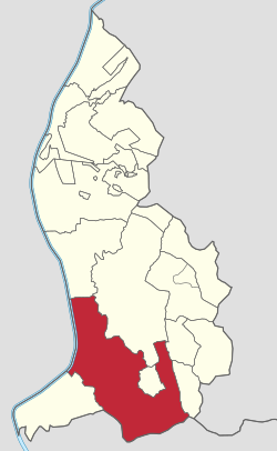
 Triesen in Liechtenstein | |
| Coordinates: 47°6′N 9°32′E / 47.100°N 9.533°E | |
| Country | |
| Electoral district | Oberland |
| Villages | Lawena, Valüna |
| Area | |
• Total | 26.47 km2 (10.22 sq mi) |
| Elevation | 512 m (1,680 ft) |
| Population (31-12-2019)[1] | |
• Total | 5,275 |
| • Density | 200/km2 (520/sq mi) |
| Time zone | UTC+1 (CET) |
| • Summer (DST) | CEST |
| Postal code | 9495 |
| Area code | 7002 |
| ISO 3166 code | LI-09 |
| Website | www.triesen.li |
Triesen (German pronunciation: [ˈtʁiːzn̩] ⓘ; dialectal: Tresa)[2] is the third largest municipality in Liechtenstein. It contains several historic churches dating from the fifteenth century. It also has a weaving mill from 1863 that is considered a historical monument. The population is around 5,275.
- ^ "Bevölkerungsstatistik" (PDF) (in German). Amt für Statistik, Fürstentum Liechtenstein. 2017-06-30.
- ^ "Triesen". Liechtensteiner Namenbuch. Retrieved 25 December 2024.

